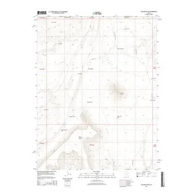
2014 Map of Factory Butte
USGS Topo · Published 2014About this map
Factory Butte dominates this high-desert landscape in Wayne County, standing as a prominent landmark north of the North Caineville Reef. The surrounding terrain is a complex network of erosional features, from the broad Factory Bench and Wood Bench to the intricate drainage systems of Salt Wash, Tank Wash, and Neilson Wash. A series of industrial-named features, including Coal Mine Wash and the associated Coal Mine Rd, suggest the historical economic interests in the area's geological layers. The southern portion of the quadrangle is defined by the massive North Caineville Mesa, while the northern reaches reveal the rolling elevations of the Moroni Slopes. This 2014 survey documents a network of unpaved access routes like Factory Butte Rd and Skyline View Rd that navigate the challenging topography of the Upper Blue Hills.
Find a feature on this map
27 named features on this map. Tap any name to fly to it.
Don’t see what you’re looking for? This feature index may not catch every label — zoom into the map to look around manually.
Map Details
Editions of this 2014 Factory Butte Map
This is the sole edition of this map. No revisions or reprints were ever made.
Other maps of this area

1885 · San Rafael
USGS Topo · 1:250,000

1885 · Fish Lake
USGS Topo · 1:250,000

1896 · Fish Lake
USGS Topo · 1:250,000

1952 · Wild Horse
USGS Topo · 1:62,500

1953 · Emery 4 SE
USGS Topo · 1:24,000

1954 · Stinking Spring Creek 3 SE
USGS Topo · 1:24,000

1954 · Stinking Spring Creek 3 SW
USGS Topo · 1:24,000

1954 · Mt. Ellen 2 SE
USGS Topo · 1:24,000

1954 · Mt. Ellen 2 SW
USGS Topo · 1:24,000

1954 · Mt. Ellen 2 NE
USGS Topo · 1:24,000