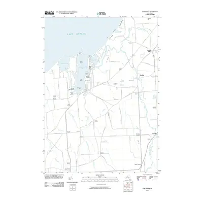
2010 Map of Fair Haven
USGS Topo · Published 2010About this map
Little Sodus Bay and Blind Sodus Bay dominate the northern shoreline of this Wayne County landscape, where the waters of Lake Ontario meet a complex series of bluffs and drumlin-like hills. The topography is defined by prominent elevations such as Wilde Hill, Juniper Hill, and the dramatic lakefront at McIntyres Bluff. Inland, the settlement pattern is characterized by historic crossroads like McKnight Corners and Grays Corners, which evolved along a network of country roads connecting small villages.
Find a feature on this map
97 named features on this map. Tap any name to fly to it.
Don’t see what you’re looking for? This feature index may not catch every label — zoom into the map to look around manually.
Map Details
Editions of this 2010 Fair Haven Map
This is the sole edition of this map. No revisions or reprints were ever made.
Other maps of this area

1900 · Oswego
USGS Topo · 1:62,500

1902 · Sodus Bay
USGS Topo · 1:62,500

1902 · Clyde
USGS Topo · 1:62,500

1902 · Weedsport
USGS Topo · 1:62,500

1943 · Oswego West
USGS Topo · 1:31,680

1943 · Cato
USGS Topo · 1:31,680

1943 · Hannibal
USGS Topo · 1:31,680

1943 · Fair Haven
USGS Topo · 1:31,680

1943 · Wolcott
USGS Topo · 1:31,680
1943 · Red Creek
USGS Topo · 1:31,680