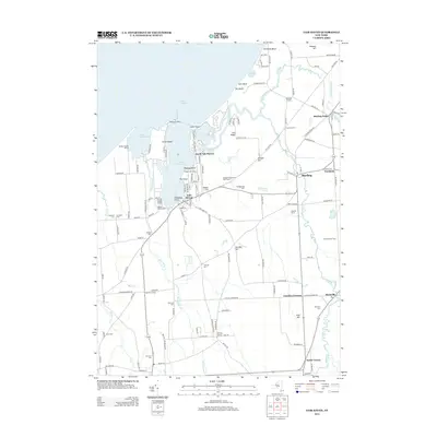
2013 Map of Fair Haven
USGS Topo · Published 2013About this map
Lake Ontario defines the northern edge of this coastal landscape, where the sheltered waters of Little Sodus Bay and Blind Sodus Bay create a deeply indented shoreline. The village of Fair Haven serves as the focal point, situated at the head of the bay near North Fair Haven and several maritime landmarks like Busters Boat Base and Chinook Harbor Marina. The surrounding terrain is characterized by a series of drumlin-like hills, including The Ridge, Juniper Hill, and Kevilles Hill, which rise above the wetlands and small water bodies like The Pond.
Find a feature on this map
138 named features on this map. Tap any name to fly to it.
Don’t see what you’re looking for? This feature index may not catch every label — zoom into the map to look around manually.
Map Details
Editions of this 2013 Fair Haven Map
This is the sole edition of this map. No revisions or reprints were ever made.
Other maps of this area

1900 · Oswego
USGS Topo · 1:62,500

1902 · Sodus Bay
USGS Topo · 1:62,500

1902 · Clyde
USGS Topo · 1:62,500

1902 · Weedsport
USGS Topo · 1:62,500

1943 · Oswego West
USGS Topo · 1:31,680

1943 · Cato
USGS Topo · 1:31,680

1943 · Hannibal
USGS Topo · 1:31,680

1943 · Fair Haven
USGS Topo · 1:31,680

1943 · Wolcott
USGS Topo · 1:31,680
1943 · Red Creek
USGS Topo · 1:31,680