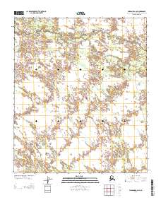
2013 Map of Fairbanks C-2 NE
USGS Topo · Published 2013About this map
Salchaket Slough and its intricate drainage network dominate this Alaskan landscape south of Fairbanks. The terrain is defined by the winding paths of McDonald Cr and Bear Creek, illustrating the complex hydrology of the Tanana Valley floor. A significant historical land route, the Bonnifield Trl, cuts through the western portion of the map, representing a vital corridor for travel and transport across the interior. The presence of this trail alongside the natural waterways highlights the intersection of early pioneer infrastructure and the persistent physical geography of the North Star Borough. The map's detail shows how the township and range lines, such as the transition from T 2 S to T 3 S, impose a geometric grid over a wilderness defined by meanders and sloughs.
Find a feature on this map
6 named features on this map. Tap any name to fly to it.
Don’t see what you’re looking for? This feature index may not catch every label — zoom into the map to look around manually.
Map Details
Editions of this 2013 Fairbanks C-2 NE Map
This is the sole edition of this map. No revisions or reprints were ever made.
Other maps of this area

1949 · Fairbanks D-1
USGS Topo · 1:62,500

1949 · Fairbanks D-2
USGS Topo · 1:62,500

1949 · Fairbanks C-1
USGS Topo · 1:63,360

1949 · Fairbanks C-2
USGS Topo · 1:63,360

1950 · Fairbanks
USGS Topo · 1:250,000

1950 · Fairbanks C-1
USGS Topo · 1:63,360

1951 · Fairbanks
USGS Topo · 1:250,000

1952 · Fairbanks C-2
USGS Topo · 1:63,360

1952 · Fairbanks D-2
USGS Topo · 1:63,360
1952 · Fairbanks C-1
USGS Topo · 1:63,360