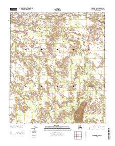
2013 Map of Fairbanks C-2 NW
USGS Topo · Published 2013About this map
Salchaket Slough and the winding reaches of Clear Cr define this landscape within the Fairbanks North Star Borough. The terrain is characterized by intricate hydrological patterns and wetlands, punctuated by the distinct elevation of Clear Creek Butte in the southeastern quadrant. This 2013 survey illustrates the sparse human footprint in this interior Alaskan region, centered on the crossing at Ester Crossing. The historical Bonnifield Trl cuts a diagonal path across the landscape, marking a significant route through the Tanana Valley. The map provides a precise look at the township and range divisions, such as the boundary between R 2 W and R 1 W, offering a clear view of the land management and topography before further modern development.
Find a feature on this map
7 named features on this map. Tap any name to fly to it.
Don’t see what you’re looking for? This feature index may not catch every label — zoom into the map to look around manually.
Map Details
Editions of this 2013 Fairbanks C-2 NW Map
This is the sole edition of this map. No revisions or reprints were ever made.
Other maps of this area

1949 · Fairbanks D-2
USGS Topo · 1:62,500

1949 · Fairbanks D-3
USGS Topo · 1:63,360

1949 · Fairbanks C-2
USGS Topo · 1:63,360

1950 · Fairbanks
USGS Topo · 1:250,000

1950 · Fairbanks C-3
USGS Topo · 1:63,360

1950 · Fairbanks D-3
USGS Topo · 1:63,360

1951 · Fairbanks
USGS Topo · 1:250,000

1952 · Fairbanks C-2
USGS Topo · 1:63,360

1952 · Fairbanks D-2
USGS Topo · 1:63,360

1952 · Fairbanks D-3
USGS Topo · 1:63,360