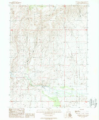
1988 Map of Fairbanks Canyon
USGS Topo · Published 1989About this map
Bull Head Ranch anchors the lower terrain of this Humboldt County quadrangle, situated where the high desert ridges meet the drainage of the Little Humboldt River. The landscape is dominated by the steep transition from Fairbanks Canyon in the northeast down toward the broader expanses of Eden Valley in the south. This 1980s landscape remains largely undeveloped, characterized by isolated water features like Eden Creek and various unnamed springs. Human infrastructure is minimal and utilitarian, consisting primarily of a Landing Strip near the ranch and a Borrow Pit nearby, reflecting the ranching and resource management needs of the era. A Gaging Sta along the river highlights the importance of water monitoring in this arid environment.
Find a feature on this map
13 named features on this map. Tap any name to fly to it.
Don’t see what you’re looking for? This feature index may not catch every label — zoom into the map to look around manually.
Map Details
Editions of this 1988 Fairbanks Canyon Map
This is the sole edition of this map. No revisions or reprints were ever made.
Other maps of this area

1882 · Paradise
USGS Topo · 1:250,000

1893 · Paradise
USGS Topo · 1:250,000

1945 · Hot Springs
USGS Topo · 1:62,500

1947 · Hot Springs Peak
USGS Topo · 1:62,500

1955 · McDermitt
USGS Topo · 1:250,000

1959 · McDermitt
USGS Topo · 1:250,000

1980 · Hardscrabble
USGS Topo · 1:24,000

1980 · Spring City
USGS Topo · 1:24,000
1980 · Chimney Reservoir
USGS Topo · 1:24,000
1980 · Whiskey Springs
USGS Topo · 1:24,000