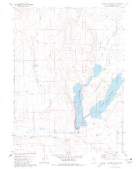
1980 Map of Chimney Reservoir
USGS Topo · Published 1980About this map
The Chimney Reservoir dominates the drainage basin of the Little Humboldt River in this 1980 survey of north-central Nevada. Formed behind the Chimney Dam, the reservoir captures the confluence of the North Fork Little Humboldt River and Chimney Creek, creating a critical water management landscape in the arid Eden Valley region. The mapping reflects a high-desert environment where water infrastructure and cattle ranching define the human footprint. Remote outposts such as North Fork Ranch and the settlement at Shadscale appear alongside traditional ranching features like a Corral and numerous Borrow Pits near the river banks. A series of Jeep Trails provides the primary access through the surrounding hills, linking isolated landmarks like Fairbanks Creek and the high point at Chimney Peak.
Find a feature on this map
17 named features on this map. Tap any name to fly to it.
Don’t see what you’re looking for? This feature index may not catch every label — zoom into the map to look around manually.
Map Details
Editions of this 1980 Chimney Reservoir Map
This is the sole edition of this map. No revisions or reprints were ever made.
Other maps of this area

1882 · Paradise
USGS Topo · 1:250,000

1893 · Paradise
USGS Topo · 1:250,000

1945 · Hot Springs
USGS Topo · 1:62,500

1947 · Hot Springs Peak
USGS Topo · 1:62,500

1955 · McDermitt
USGS Topo · 1:250,000

1959 · McDermitt
USGS Topo · 1:250,000
1980 · Layton Spring
USGS Topo · 1:24,000

1980 · Hardscrabble
USGS Topo · 1:24,000
1980 · Kenny Creek
USGS Topo · 1:24,000
1980 · Greeley Flat SE
USGS Topo · 1:24,000