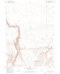
1980 Map of Greeley Flat SE
USGS Topo · Published 1980About this map
The North Fork Humboldt River carves a deep path through the high desert of northern Nevada, defining the western portion of this 1980 survey. This area, straddling the Humboldt Co Elko Co line, reflects the ranching and livestock history of the Great Basin. Evidence of land use is visible in the presence of a Corral and New Reservoir, suggesting seasonal grazing and water management in an otherwise arid environment. Travel through the eastern hills is limited to a primitive Jeep Trail, which winds past Milligan Creek and an unnamed Spring. The map documents a sparsely populated landscape where geographical features and water sources dictate the movement of people and livestock across the county border.
Find a feature on this map
8 named features on this map. Tap any name to fly to it.
Don’t see what you’re looking for? This feature index may not catch every label — zoom into the map to look around manually.
Map Details
Editions of this 1980 Greeley Flat SE Map
This is the sole edition of this map. No revisions or reprints were ever made.
Other maps of this area

1882 · Paradise
USGS Topo · 1:250,000

1893 · Paradise
USGS Topo · 1:250,000

1955 · McDermitt
USGS Topo · 1:250,000

1959 · McDermitt
USGS Topo · 1:250,000
1973 · Rodear Flat
USGS Topo · 1:24,000

1973 · Button Lake Well
USGS Topo · 1:24,000

1973 · Humboldt Hill
USGS Topo · 1:24,000
1980 · Layton Spring
USGS Topo · 1:24,000
1980 · Button Lake
USGS Topo · 1:24,000

1980 · Greeley Flat
USGS Topo · 1:24,000