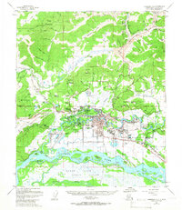
1965 Map of Fairbanks D-2
USGS Topo · Published 1966About this map
Fairbanks serves as the focal point of this interior Alaskan landscape, showing a period of significant mid-century expansion. The urban core is surrounded by developing neighborhoods like Lemeta, Slaterville, and Hamilton Acres, while the University of Alaska sits prominently to the west near College. The presence of Fort Wainwright and the International Airport underscores the region's strategic importance during the Cold War era.
Find a feature on this map
100 named features on this map. Tap any name to fly to it.
Don’t see what you’re looking for? This feature index may not catch every label — zoom into the map to look around manually.
Map Details
Editions of this 1965 Fairbanks D-2 Map
This is the sole edition of this map. No revisions or reprints were ever made.
Other maps of this area

1945 · Livengood
USGS Topo · 1:250,000

1949 · Fairbanks D-1
USGS Topo · 1:62,500

1949 · Fairbanks D-2
USGS Topo · 1:62,500

1949 · Fairbanks C-1
USGS Topo · 1:63,360

1949 · Fairbanks D-3
USGS Topo · 1:63,360

1949 · Fairbanks C-2
USGS Topo · 1:63,360

1950 · Fairbanks
USGS Topo · 1:250,000

1950 · Fairbanks C-3
USGS Topo · 1:63,360

1950 · Fairbanks C-1
USGS Topo · 1:63,360

1950 · Fairbanks D-3
USGS Topo · 1:63,360