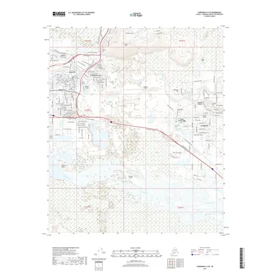
2017 Map of Fairbanks D-2 SE
USGS Topo · Published 2017About this map
The Chena River and Tanana River define the intricate waterways and lowlands of the Fairbanks area, where modern infrastructure meets the vast Alaskan landscape. Residential developments such as Lemeta, Slaterville, and Hamilton Acres are situated near the city center, while the large expanse of Ladd Army Airfield dominates the central portion of the map, signifying the long-standing military presence in the region. To the north, Birch Hill rises above the river valley, hosting the Birch Hill Cem. The map reveals how the city has grown around natural features like Bentley Island and Noyes Slough, with newer neighborhoods like Dennis Manor and Badger extending to the east. Several smaller airfields, including Metro Field, highlight the critical role of aviation in this interior Alaskan hub, while the sprawling braids of the Tanana River at the south provide a stark contrast to the structured street grids of the urban core.
Find a feature on this map
164 named features on this map. Tap any name to fly to it.
Don’t see what you’re looking for? This feature index may not catch every label — zoom into the map to look around manually.
Map Details
Editions of this 2017 Fairbanks D-2 SE Map
This is the sole edition of this map. No revisions or reprints were ever made.
Other maps of this area

1949 · Fairbanks D-1
USGS Topo · 1:62,500

1949 · Fairbanks D-2
USGS Topo · 1:62,500

1949 · Fairbanks C-1
USGS Topo · 1:63,360

1949 · Fairbanks C-2
USGS Topo · 1:63,360

1950 · Fairbanks
USGS Topo · 1:250,000

1950 · Fairbanks C-1
USGS Topo · 1:63,360

1951 · Fairbanks
USGS Topo · 1:250,000

1952 · Fairbanks C-2
USGS Topo · 1:63,360

1952 · Fairbanks D-2
USGS Topo · 1:63,360
1952 · Fairbanks C-1
USGS Topo · 1:63,360
Featured Places
- Fairbanks, AK
- Hamilton Acres, Fairbanks
- Lemeta, Fairbanks
- Slaterville, Fairbanks
- Fairbanks North Star, AK