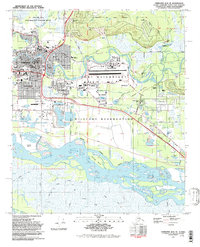
1992 Map of Fairbanks D-2 SE
USGS Topo · Published 1992About this map
Fort Wainwright Military Reservation dominates the eastern half of this landscape, showcasing the extensive military footprint adjacent to central Fairbanks. The city's residential and institutional core is highly detailed, featuring a dense network of schools such as Ryan Jr HS and Lathrop High Sch, alongside landmarks like Fairbanks Mem Hosp and the Immaculate Conception Sch. The area is geographically defined by the Chena River winding through the city and the wide braids of the Tanana River to the south, where Meridian Island sits amidst the shifting channels.
Find a feature on this map
69 named features on this map. Tap any name to fly to it.
Don’t see what you’re looking for? This feature index may not catch every label — zoom into the map to look around manually.
Map Details
Editions of this 1992 Fairbanks D-2 SE Map
This is the sole edition of this map. No revisions or reprints were ever made.
Other maps of this area

1949 · Fairbanks D-1
USGS Topo · 1:62,500

1949 · Fairbanks D-2
USGS Topo · 1:62,500

1949 · Fairbanks C-1
USGS Topo · 1:63,360

1949 · Fairbanks C-2
USGS Topo · 1:63,360

1950 · Fairbanks
USGS Topo · 1:250,000

1950 · Fairbanks C-1
USGS Topo · 1:63,360

1951 · Fairbanks
USGS Topo · 1:250,000

1952 · Fairbanks C-2
USGS Topo · 1:63,360

1952 · Fairbanks D-2
USGS Topo · 1:63,360
1952 · Fairbanks C-1
USGS Topo · 1:63,360
Featured Places
- Fairbanks, AK
- Lemeta, Fairbanks
- Slaterville, Fairbanks
- Hamilton Acres, Fairbanks
- Fairbanks North Star, AK