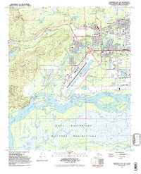
1992 Map of Fairbanks D-2 SW
USGS Topo · Published 1992About this map
The Chena River and Alaska Railroad serve as the industrial and logistical backbone of this interior Alaskan landscape in the early 1990s. This survey detail captures the complex transition from the urban core of Fairbanks and its neighboring communities like College and Aurora to the expansive braided channels of the Tanana River to the south. The presence of the University of Alaska, West Valley High Sch, and the Tanana Valley Community College highlights the area's role as a regional educational hub, while the massive footprint of Fairbanks International Airport, complete with its Sea Plane Base, emphasizes its critical importance for Arctic transport.
Find a feature on this map
65 named features on this map. Tap any name to fly to it.
Don’t see what you’re looking for? This feature index may not catch every label — zoom into the map to look around manually.
Map Details
Editions of this 1992 Fairbanks D-2 SW Map
2 editions found
Other maps of this area

1949 · Fairbanks D-2
USGS Topo · 1:62,500

1949 · Fairbanks D-3
USGS Topo · 1:63,360

1949 · Fairbanks C-2
USGS Topo · 1:63,360

1950 · Fairbanks
USGS Topo · 1:250,000

1950 · Fairbanks C-3
USGS Topo · 1:63,360

1950 · Fairbanks D-3
USGS Topo · 1:63,360

1951 · Fairbanks
USGS Topo · 1:250,000

1952 · Fairbanks C-2
USGS Topo · 1:63,360

1952 · Fairbanks D-2
USGS Topo · 1:63,360

1952 · Fairbanks D-3
USGS Topo · 1:63,360