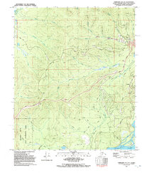
1992 Map of Fairbanks D-3 SE
USGS Topo · Published 1992About this map
The gold-mining legacy of the Fairbanks district is clearly visible on this 1992 survey, centered on the historic mining camp of Ester. Extensive Tailings and multiple Prospects line the drainages of Ester Creek and Ready Bullion Creek, where an Open Pit Mine marks the industrial activity of the late 20th century. This landscape is a complex mix of extraction and preservation, with the Bonanza Creek Experimental Forest occupying the southwest, providing a buffer of managed wilderness against the development spreading from the George Parks Highway.
Find a feature on this map
36 named features on this map. Tap any name to fly to it.
Don’t see what you’re looking for? This feature index may not catch every label — zoom into the map to look around manually.
Map Details
Editions of this 1992 Fairbanks D-3 SE Map
This is the sole edition of this map. No revisions or reprints were ever made.
Other maps of this area

1949 · Fairbanks D-2
USGS Topo · 1:62,500

1949 · Fairbanks D-3
USGS Topo · 1:63,360

1949 · Fairbanks C-2
USGS Topo · 1:63,360

1950 · Fairbanks
USGS Topo · 1:250,000

1950 · Fairbanks C-3
USGS Topo · 1:63,360

1950 · Fairbanks D-3
USGS Topo · 1:63,360

1951 · Fairbanks
USGS Topo · 1:250,000

1952 · Fairbanks C-2
USGS Topo · 1:63,360

1952 · Fairbanks D-2
USGS Topo · 1:63,360

1952 · Fairbanks D-3
USGS Topo · 1:63,360