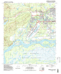
1992 Map of Fairbanks D-3 SW
USGS Topo · Published 1992About this map
The University of Alaska campus serves as a central landmark in this 1990s Alaskan landscape, where the academic grounds at College meet the industrial and transportation corridors of the Alaska Railroad. To the south, the expansive Fort Wainwright Military Reservation dominates the terrain below the braided channels of the Tanana River and the winding Chena River. The map captures a high degree of institutional development, featuring the Fairbanks International Airport, the State Prison, and a Youth Correctional Facility.
Find a feature on this map
51 named features on this map. Tap any name to fly to it.
Don’t see what you’re looking for? This feature index may not catch every label — zoom into the map to look around manually.
Map Details
Editions of this 1992 Fairbanks D-3 SW Map
This is the sole edition of this map. No revisions or reprints were ever made.
Other maps of this area

1949 · Fairbanks D-3
USGS Topo · 1:63,360

1949 · Fairbanks D-4
USGS Topo · 1:63,360

1950 · Fairbanks
USGS Topo · 1:250,000

1950 · Fairbanks C-3
USGS Topo · 1:63,360

1950 · Fairbanks C-4
USGS Topo · 1:63,360

1950 · Fairbanks D-3
USGS Topo · 1:63,360

1951 · Fairbanks
USGS Topo · 1:250,000

1952 · Fairbanks C-4
USGS Topo · 1:63,360

1952 · Fairbanks D-3
USGS Topo · 1:63,360

1952 · Fairbanks D-4
USGS Topo · 1:63,360