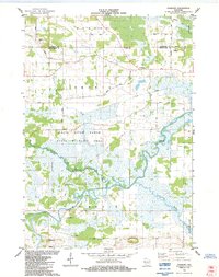
1984 Map of Fairburn
USGS Topo · Published 1984About this map
The White River Marsh State Wildlife Area dominates this central Wisconsin landscape, where the White River and Fox River converge in a complex network of wetlands and seasonal drainages. In the mid-1980s, the small settlement of Fairburn sat at the junction of several county roads, serving as a focal point for the surrounding agricultural townships of Warren, Seneca, and St Marie. The map reveals a hydrographic pattern where the Puchyan River and Huckleberry River snake through the lowlands, contrasted by the sudden elevation of Mt Tom in the south.
Find a feature on this map
32 named features on this map. Tap any name to fly to it.
Don’t see what you’re looking for? This feature index may not catch every label — zoom into the map to look around manually.
Map Details
Editions of this 1984 Fairburn Map
This is the sole edition of this map. No revisions or reprints were ever made.
Other maps of this area

1915 · Neshkoro
USGS Topo · 1:48,000

1916 · Ripon
USGS Topo · 1:48,000

1918 · Neshkoro
USGS Topo · 1:62,500

1918 · Ripon
USGS Topo · 1:62,500

1955 · Green Bay
USGS Topo · 1:250,000

1956 · Ripon
USGS Topo · 1:62,500

1957 · Madison
USGS Topo · 1:250,000

1960 · Madison
USGS Topo · 1:250,000

1961 · Poy Sippi
USGS Topo · 1:62,500

1961 · Redgranite
USGS Topo · 1:62,500