
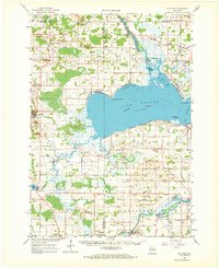
1961 Map of Poy Sippi
USGS Topo · Published 1963About this map
Lake Poygan dominates the central landscape of this early 1960s survey, surrounded by a complex network of waterways including the Wolf River and Fox River. The map details a rural Wisconsin geography where small dairy-era settlements like Poy Sippi, Tustin, and West Bloomfield serve as local hubs. The abundance of drainage features, such as Mosquito Creek and the Poygan Marsh, alongside specialized agriculture like the Cranberry Bog near Auroraville, illustrates the region's historical reliance on its wetlands and river systems.
Find a feature on this map
77 named features on this map. Tap any name to fly to it.
Don’t see what you’re looking for? This feature index may not catch every label — zoom into the map to look around manually.
Map Details
Editions of this 1961 Poy Sippi Map
2 editions found
Other maps of this area

1915 · Neshkoro
USGS Topo · 1:48,000

1916 · Ripon
USGS Topo · 1:48,000

1918 · Neshkoro
USGS Topo · 1:62,500

1918 · Ripon
USGS Topo · 1:62,500

1955 · Green Bay
USGS Topo · 1:250,000

1956 · Ripon
USGS Topo · 1:62,500

1956 · Rosendale
USGS Topo · 1:62,500

1956 · New London
USGS Topo · 1:48,000

1956 · Weyauwega
USGS Topo · 1:48,000

1957 · Waupaca
USGS Topo · 1:48,000