
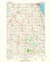
1956 Map of Rosendale
USGS Topo · Published 1957About this map
Lake Winnebago defines the eastern edge of this mid-1950s landscape, with lakeside settlements like Paukotuk and Stony Beach nestled along the shoreline near the southern outskirts of Oshkosh. Inland, the map reveals a dense rural network of family farms and local institutions, characterized by an exceptionally high number of neighborhood schoolhouses such as High Ridge Sch, Triangle Sch, and Goldenrod Sch. Several of these, including Maple Sch and Tice Sch, are explicitly marked as abandoned, signaling a transition in rural education during this era.
Find a feature on this map
100 named features on this map. Tap any name to fly to it.
Don’t see what you’re looking for? This feature index may not catch every label — zoom into the map to look around manually.
Map Details
Editions of this 1956 Rosendale Map
2 editions found
Other maps of this area

1910 · Fond du Lac
USGS Topo · 1:62,500

1911 · Neenah
USGS Topo · 1:62,500

1916 · Ripon
USGS Topo · 1:48,000

1918 · Ripon
USGS Topo · 1:62,500

1955 · Neenah
USGS Topo · 1:62,500

1955 · Waupun
USGS Topo · 1:62,500

1955 · Campbellsport
USGS Topo · 1:62,500

1955 · Fox Lake
USGS Topo · 1:62,500

1955 · Fond Du Lac
USGS Topo · 1:62,500

1955 · Fond Du Lac
USGS Topo · 1:24,000