
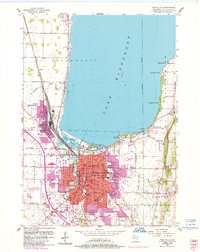
1955 Map of Fond Du Lac
USGS Topo · Published 1966About this map
The southern shores of Lake Winnebago define the landscape in this mid-century survey, where the concentrated urban core of Fond Du Lac meets the agricultural townships of Friendship and Empire. The city's mid-1950s infrastructure is clearly visible, from the Fond Du Lac Airport and the Sky Harbor Seaplane Base to the extensive rail yards of the Chicago and North Western and Minneapolis St Paul and Sault Ste Marie railroads.
Find a feature on this map
60 named features on this map. Tap any name to fly to it.
Don’t see what you’re looking for? This feature index may not catch every label — zoom into the map to look around manually.
Map Details
Editions of this 1955 Fond Du Lac Map
2 editions found
Other maps of this area

1910 · Fond du Lac
USGS Topo · 1:62,500

1955 · Waupun
USGS Topo · 1:62,500

1955 · Campbellsport
USGS Topo · 1:62,500

1955 · Fond Du Lac
USGS Topo · 1:62,500

1956 · Rosendale
USGS Topo · 1:62,500

1957 · Madison
USGS Topo · 1:250,000

1960 · Madison
USGS Topo · 1:250,000
1974 · St. Peter
USGS Topo · 1:24,000
1974 · Fahrney Point
USGS Topo · 1:24,000
1974 · Brothertown
USGS Topo · 1:24,000