Old Maps of Fond du Lac County, Wisconsin
Explore 170 old maps of Fond du Lac County, spanning from 1910 to today. These high-resolution historic maps reveal how streets, neighborhoods, landmarks, and natural features evolved over time — perfect for genealogy, metal detecting, research, and local history exploration.
What you can do with these maps:
- See how Fond du Lac County changed over time: Compare historical maps to modern-day views to trace roads, homesites, rail lines & more.
- View detailed metadata: Each map includes creators, publishers, year, scale, and archive source.
- Overlay maps with satellite & LiDAR: Visualize the past alongside modern tools to explore terrain & human change.
- Trusted historical sources: Maps sourced from the USGS, Library of Congress, and other archives.
- Access maps your way: View online, download high-res files, or order prints for personal or research use.
Start exploring old maps of Fond du Lac County to uncover forgotten places, hidden landmarks, and the deep history beneath your feet.
Fond du Lac County, WI maps
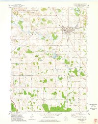
(170)- 1910 Map of Fond du Lac
 1910 Fond du Lac1910 Print · USGSThe southern shores of Lake Winnebago appear in high detail during this era of rapid railroad expansion and agricultural growth. Genealogists and local historians can trace early property locations near Rienzi Cemetery, Brothertown, and the busy rail yards of North Fond du Lac.2 unique versions available
 - 1916 Map of Ripon
 1916 Ripon1916 Print · USGSWisconsin’s Fox River Valley and the lakelands of Fond du Lac and Winnebago counties are captured here just before the close of the Great War. Genealogists can trace family roots through dozens of rural landmarks, from Center House to Fera School and the Eureka Lock.
 - 1918 Map of Ripon
 1918 Ripon1918 Print · USGSFond du Lac and Green Lake counties are shown here at the end of the Great War, when the rail lines still dictated the pace of commerce. Researchers can trace the early boundaries of Berlin and Ripon or locate rural landmarks like the Arcade School and Koro.
 - 1954 Map of Kiel, 1956 Print
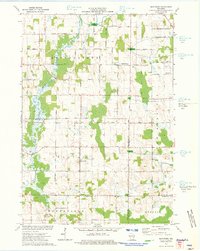
 1954 Kiel1956 Print · USGSWisconsin's glacial landscape meets mid-century development in this survey of the four-county border region. Genealogists can trace family roots through numerous country churches like Holy Rosary Ch and schools including the Elder Grove Sch.2 unique versions available
 - 1955 Map of Waupun, 1957 Print
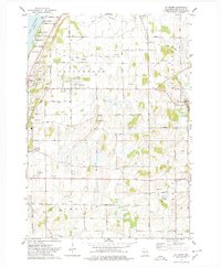
 1955 Waupun1957 Print · USGSIn the mid-1950s, the Dodge and Fond du Lac county border was defined by the massive wetland expanse of the Horicon Marsh. Genealogists and local historians can trace rural school locations like Cattaraugus Sch and the institutional grounds of the State Prison in Waupun.2 unique versions available
 - 1955 Map of Campbellsport, 1957 Print
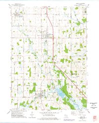
 1955 Campbellsport1957 Print · USGSThe Fond du Lac countryside in the mid-fifties shows a landscape of limestone quarries and rail-fed village centers. Genealogists can locate family landmarks like Silver Leaf Sch, Marblehead Quarries, and the Empire Cem.2 unique versions available
 - 1955 Map of Fox Lake, 1957 Print
 1955 Fox Lake1957 Print · USGSIn the mid-1950s, the Dodge and Green Lake County borderlands were defined by a high density of one-room schoolhouses and rail-dependent towns. Trace family roots at Tichora Cem or follow the old Milwaukee Road tracks through Markesan and Fox Lake Junction.
 - 1955 Map of Kewaskum, 1957 Print
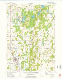
 1955 Kewaskum1957 Print · USGSMid-century eastern Wisconsin comes alive in this survey of the glacial Kettle Moraine region. Genealogists and historians can locate rural landmarks like Conners Mill, the Parnell Lookout Tower, and old schools including Mitchell Sch and Hillside Sch.4 unique versions available
 - 1955 Map of Fond Du Lac, 1957 Print
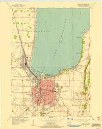
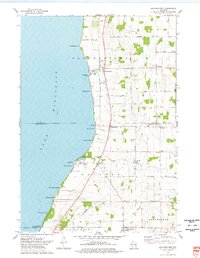
 1955 Fond Du Lac1957 Print · USGSMid-century Fond du Lac County unfolds along the eastern shore of Lake Winnebago, where bustling city streets meet a coastline dotted with summer beaches and seaplane bases. Genealogists can trace family roots through Rienzi Cem, local parish schools like St Pauls Sch, and rural hamlets such as Taycheedah and Pipe.2 unique versions available
 - 1955 Map of Fond Du Lac, 1966 Print
 1955 Fond Du Lac1966 Print · USGSFond du Lac at the edge of the lake in the mid-fifties shows a bustling hub of rail, aviation, and education. Trace the development of Marian College, the sprawling rail yards in North Fond du Lac, and lakeside spots like Lakeside Park.2 unique versions available
 - 1956 Map of Ripon, 1957 Print
 1956 Ripon1957 Print · USGSRipon and the surrounding Wisconsin lakelands are shown in the mid-fifties as the region's rail and agricultural patterns remained firmly intact. Researchers can locate numerous rural schoolhouses like Prairie Lawn Sch and trace the legacy of Ripon College or the historic settlement of Sacramento.
 - 1956 Map of Rosendale, 1957 Print
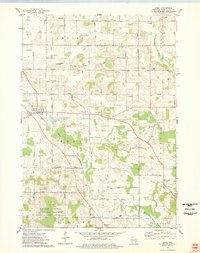
 1956 Rosendale1957 Print · USGSWisconsin's farm country meets the shores of Lake Winnebago in the mid-fifties, just as the rural schoolhouse era was fading. Researchers can trace dozens of local landmarks like Paukotuk, Woodhull (Station), and several abandoned sites like Knott Sch.2 unique versions available
 - 1957 Map of Madison, 1967 Print
 1957 Madison1967 Print · USGSSouth-central Wisconsin in the mid-fifties reveals a landscape of industrial hubs and glacial lakes linked by a dense rail and highway network. Genealogists and historians can trace the development of lakeside communities and find notable sites like Badger Ordnance Works and the Horicon National Wildlife Refuge.3 unique versions available
 - 1960 Map of Madison
 1960 Madison1960 Print · USGSCentral and Southern Wisconsin are captured in the late fifties, showing the region as its rail-and-river network matured. Trace the paths of the Soo Line RR or locate family roots near Lake Mendota and Horicon National Wildlife Refuge.2 unique versions available
 - 1974 Map of St. Cloud, 1977 Print
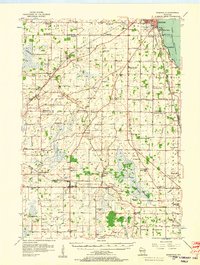
 1974 St. Cloud1977 Print · USGSFond du Lac and Sheboygan counties are captured in the mid-seventies, showing a landscape defined by conservation and glacial water. Genealogists can locate family landmarks like Forest Home Cem, St Joseph Ch, and the historic St Lawrence Seminary.
 - 1974 Map of Dundee, 1977 Print
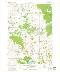
 1974 Dundee1977 Print · USGSThe glacial landscapes of Fond du Lac and Sheboygan counties are captured here in the mid-seventies, showing the intersection of conservation and rural life. Researchers can trace family sites at Union Cem and Trinity Cem or locate the old Townhall near Mud Lake.2 unique versions available
 - 1974 Map of Marytown, 1977 Print
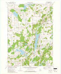
 1974 Marytown1977 Print · USGSEastern Wisconsin dairy country is captured here in the mid-seventies at the meeting of Calumet, Fond du Lac, and Sheboygan counties. Genealogists can trace family farm locations near Marytown, Charlesburg, and the St Charles Cem.
 - 1974 Map of Kewaskum, 1977 Print
 1974 Kewaskum1977 Print · USGSThe glacial landscapes of Washington and Sheboygan Counties are on full display in the mid-1970s, showcasing the intricate network of lakes and kettle formations. Researchers can trace rural life through the New Fane Millpond, early cemeteries like New Prospect Cem, and the Chicago and North Western rail corridor.
 - 1974 Map of St. Peter, 1978 Print
 1974 St. Peter1978 Print · USGSThe eastern shore of Lake Winnebago meets the rural hills of Fond du Lac County in the mid-1970s. Genealogists and local historians can trace the foundations of St Peter, locate the Taycheedah Cem, and follow the Old Railroad Grade through Silica.
 - 1974 Map of Fahrney Point, 1978 Print
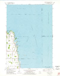 1974 Fahrney Point1978 Print · USGSThe western shores of Lake Winnebago are captured here in the mid-1970s, showing a mix of established lakeside retreats and expanding rural road networks. Trace the development of waterfront communities like Point Comfort and Decorah Beach or locate family-named landmarks such as Oaklawn Cem and the Jesuit Retreat.
 - 1974 Map of Brothertown, 1978 Print
 1974 Brothertown1978 Print · USGSThe eastern shores of Lake Winnebago come into focus during the mid-seventies, showing a landscape defined by historic county boundaries and shoreline developments. Genealogists and local researchers can trace sites like Union Cemetery, the crossroads at Jericho, and the lakeside community of Artesia Beach.
 - 1974 Map of Campbellsport, 1978 Print
 1974 Campbellsport1978 Print · USGSWisconsin's glacial legacy is on full display in the 1970s, as drumlin ridges and marshes define the landscape around Campbellsport. Family historians can locate several rural burial grounds like Union Cem and Deutsche Bisch Cem or trace the Chicago and North Western rail line.
 - 1974 Map of Eden, 1978 Print
 1974 Eden1978 Print · USGSFond du Lac County is shown in the mid-1970s, characterized by its distinctive glacial drumlin formations and rural townships. Researchers can trace historic family burial sites at Empire Cem and Gudex Cem or follow the path of the Chicago and North Western rail line.
 - 1974 Map of Byron, 1978 Print
 1974 Byron1978 Print · USGSThe limestone quarries and rail lines of the Wisconsin Escarpment are captured here in the 1970s. Local researchers can trace family roots in Hamilton and South Byron or locate old industrial sites like the Kilns in Marblehead.
 - 1974 Map of Lomira, 1978 Print
 1974 Lomira1978 Print · USGSDodge County's glacial landscape and wetland conservation are captured here in the mid-seventies, featuring the expansive Theresa Marsh State Wildlife Area. Researchers can trace local heritage through numerous sites like Wayne Cem, St Pauls Sch, and the old rail stop at Theresa Station.
Showing maps 1-25 of 170
Top cities of Fond du Lac County
- Fond du Lac historical maps
- Ripon historical maps
- North Fond du Lac historical maps
- Taycheedah historical maps
- Campbellsport historical maps
- Ashford historical maps
See more
Frequently asked questions
- What are the different types of historical maps available for Fond du Lac County?
- What is the oldest map of Fond du Lac County?
- Where can I purchase historical maps of Fond du Lac County for my home or office?
- Where can I download high-res historical maps of Fond du Lac County?
- Are there historical topographic maps available for Fond du Lac County?
- Is there historical aerial imagery available for Fond du Lac County?
- Where are historical maps of Fond du Lac County sourced from?