1980s Maps of Fond du Lac County, Wisconsin
Explore 13 historic maps of Fond du Lac County from the 1980s. These maps offer a rare glimpse into what life looked like during the 1980s — showing old roads, neighborhoods, homes, and landmarks that have changed or disappeared over time.
Whether you're researching your family's past, planning a metal detecting trip, or studying how Fond du Lac County's landscape evolved across the 1980s, these high-resolution maps are a powerful tool for exploring the history of this region.
- Focus on a specific era: All maps on this page are from the 1980s, giving you a focused view of this time period.
- See what’s changed: Compare century-old streets, trails, and buildings to today's modern landscape using overlays and satellite layers.
- Research with precision: Use these maps for genealogy, historical research, land use analysis, or educational projects.
- View, download, or print: Maps are fully viewable online in high resolution, and can be downloaded or printed for your own records.
Start exploring Fond du Lac County's history through authentic maps from the 1980s. This is your window into the past.
Fond du Lac County, WI maps
(13)- 1980 Map of Fond Du Lac
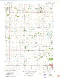
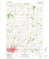
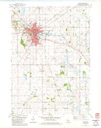
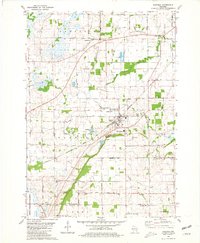
 1980 Fond Du Lac1980 Print · USGSThe Fox River Valley and Horicon Marsh meet here during the late twentieth century, showing a transition from lakeside industry to glacial conservation. Genealogists can locate family sites at Estabrook Cem or trace the rail lines through Ripon and Waupun.
 - 1980 Map of Brandon, 1981 Print
 1980 Brandon1981 Print · USGSBrandon and its surrounding townships are shown here in the late seventies, a landscape shaped by the headwaters of the Rock River and the local rail line. Genealogists can locate several rural burial grounds including Union Prairie Cem and Wood Cem near Fairwater.
 - 1980 Map of Green Lake, 1981 Print
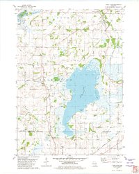
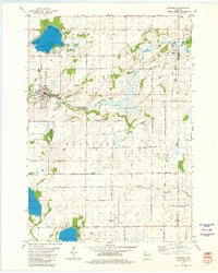
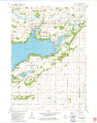 1980 Green Lake1981 Print · USGSGreen Lake at the start of the eighties shows a thriving waterfront community defined by its deep bays and emerging residential pockets. Genealogists and local historians can trace legacy sites like Dartford Cem, Center House, and the sprawling Fairground.
 - 1980 Map of Pickett, 1981 Print
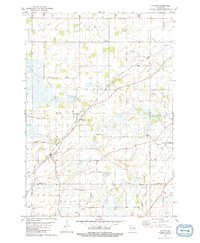 1980 Pickett1981 Print · USGSCrossing Winnebago and Fond du Lac counties in the late seventies, this survey shows a thriving rural landscape linked by rail and private airstrips. Local historians can trace family roots at Liberty Prairie Cem, visit Zoar Ch, or locate old schools like Utica Center Sch.
 - 1980 Map of Eldorado, 1981 Print
 1980 Eldorado1981 Print · USGSFond du Lac County in the early eighties is defined here by the great Eldorado Marsh and its surrounding rural hamlets. Trace family history through Anderson Cem, Elmwood Sch, and the Chicago and North Western rail corridor.
 - 1980 Map of Waupun North, 1981 Print
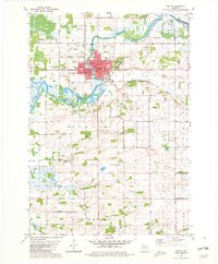
 1980 Waupun North1981 Print · USGSThe city of Waupun and its surrounding townships are shown here in the early eighties, just as the local rail and prison systems remained central to the town's identity. Researchers can trace family roots through numerous sites like Cattaraugus Cem, Amity Sch, and the State Prison Farm.
 - 1980 Map of Ripon, 1981 Print
 1980 Ripon1981 Print · USGSRipon and its surrounding townships show a thriving college town and agricultural landscape in the late 1970s. Researchers can trace historic rail corridors and local landmarks like Ripon College, Gothic Millpond, and the rural settlement of Reeds Corners.
 - 1980 Map of Rush Lake, 1981 Print
 1980 Rush Lake1981 Print · USGSWinnebago County in the late seventies and early eighties shows a landscape of glacial lakes and quiet crossroads. Genealogists and local historians can trace family roots through several rural burial grounds like Nepeuskun Cem and Loper Cem.
 - 1980 Map of Van Dyne, 1981 Print
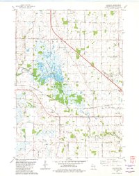
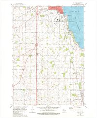 1980 Van Dyne1981 Print · USGSWinnebago and Fond du Lac counties meet along the shores of Lake Winnebago in the early eighties. Local historians can trace established lakefront settlements like Paukotuk and rural landmarks such as Lakeside Sch and St Johns Cem.
 - 1980 Map of Oakfield, 1981 Print
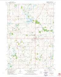
 1980 Oakfield1981 Print · USGSCentral Fond du Lac County is shown in the late seventies as a busy rail and quarrying hub. Researchers can locate family sites near Oak Center, the Belle Reynolds Sch, and the Soo Line tracks.
 - 1980 Map of Markesan, 1981 Print
 1980 Markesan1981 Print · USGSMarkesan and the surrounding Mackford township are shown in the early 1980s as the rail and river landscape evolved. You can locate family history markers like Memorial Cem, the Prairie View Sch, and the Utley quarry works.
 - 1980 Map of Rosendale, 1981 Print
 1980 Rosendale1981 Print · USGSThe village of Rosendale and the surrounding townships of Springvale and Lamartine are captured in the late 1970s. Trace local history at St Marys Ch, the Laconia High Sch, or along the Chicago and North Western railroad.
 - 1980 Map of Berlin, 1981 Print
 1980 Berlin1981 Print · USGSThe Fox River valley in Green Lake County appears here during the early eighties, centered on the historic city of Berlin. Researchers can trace family sites among several country churches and cemeteries, including St Stanislaus Cem, or locate rural schools like Lamberton Sch.
End of results
Showing maps 1-13 of 13
Top cities of Fond du Lac County
- Fond du Lac historical maps
- Ripon historical maps
- North Fond du Lac historical maps
- Taycheedah historical maps
- Campbellsport historical maps
- Ashford historical maps
See more
Frequently asked questions
- What are the different types of historical maps available for Fond du Lac County?
- What is the oldest map of Fond du Lac County?
- Where can I purchase historical maps of Fond du Lac County for my home or office?
- Where can I download high-res historical maps of Fond du Lac County?
- Are there historical topographic maps available for Fond du Lac County?
- Is there historical aerial imagery available for Fond du Lac County?
- Where are historical maps of Fond du Lac County sourced from?