1950s Maps of Fond du Lac County, Wisconsin
Explore 10 historic maps of Fond du Lac County from the 1950s. These maps offer a rare glimpse into what life looked like during the 1950s — showing old roads, neighborhoods, homes, and landmarks that have changed or disappeared over time.
Whether you're researching your family's past, planning a metal detecting trip, or studying how Fond du Lac County's landscape evolved across the 1950s, these high-resolution maps are a powerful tool for exploring the history of this region.
- Focus on a specific era: All maps on this page are from the 1950s, giving you a focused view of this time period.
- See what’s changed: Compare century-old streets, trails, and buildings to today's modern landscape using overlays and satellite layers.
- Research with precision: Use these maps for genealogy, historical research, land use analysis, or educational projects.
- View, download, or print: Maps are fully viewable online in high resolution, and can be downloaded or printed for your own records.
Start exploring Fond du Lac County's history through authentic maps from the 1950s. This is your window into the past.
Fond du Lac County, WI maps
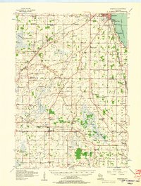
(10)- 1954 Map of Kiel, 1956 Print
 1954 Kiel1956 Print · USGSWisconsin's glacial landscape meets mid-century development in this survey of the four-county border region. Genealogists can trace family roots through numerous country churches like Holy Rosary Ch and schools including the Elder Grove Sch.2 unique versions available
 - 1955 Map of Waupun, 1957 Print
 1955 Waupun1957 Print · USGSIn the mid-1950s, the Dodge and Fond du Lac county border was defined by the massive wetland expanse of the Horicon Marsh. Genealogists and local historians can trace rural school locations like Cattaraugus Sch and the institutional grounds of the State Prison in Waupun.2 unique versions available
 - 1955 Map of Campbellsport, 1957 Print
 1955 Campbellsport1957 Print · USGSThe Fond du Lac countryside in the mid-fifties shows a landscape of limestone quarries and rail-fed village centers. Genealogists can locate family landmarks like Silver Leaf Sch, Marblehead Quarries, and the Empire Cem.2 unique versions available
 - 1955 Map of Fox Lake, 1957 Print
 1955 Fox Lake1957 Print · USGSIn the mid-1950s, the Dodge and Green Lake County borderlands were defined by a high density of one-room schoolhouses and rail-dependent towns. Trace family roots at Tichora Cem or follow the old Milwaukee Road tracks through Markesan and Fox Lake Junction.
 - 1955 Map of Kewaskum, 1957 Print
 1955 Kewaskum1957 Print · USGSMid-century eastern Wisconsin comes alive in this survey of the glacial Kettle Moraine region. Genealogists and historians can locate rural landmarks like Conners Mill, the Parnell Lookout Tower, and old schools including Mitchell Sch and Hillside Sch.4 unique versions available
 - 1955 Map of Fond Du Lac, 1957 Print
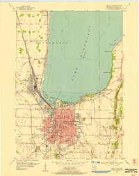
 1955 Fond Du Lac1957 Print · USGSMid-century Fond du Lac County unfolds along the eastern shore of Lake Winnebago, where bustling city streets meet a coastline dotted with summer beaches and seaplane bases. Genealogists can trace family roots through Rienzi Cem, local parish schools like St Pauls Sch, and rural hamlets such as Taycheedah and Pipe.2 unique versions available
 - 1955 Map of Fond Du Lac, 1966 Print
 1955 Fond Du Lac1966 Print · USGSFond du Lac at the edge of the lake in the mid-fifties shows a bustling hub of rail, aviation, and education. Trace the development of Marian College, the sprawling rail yards in North Fond du Lac, and lakeside spots like Lakeside Park.2 unique versions available
 - 1956 Map of Ripon, 1957 Print
 1956 Ripon1957 Print · USGSRipon and the surrounding Wisconsin lakelands are shown in the mid-fifties as the region's rail and agricultural patterns remained firmly intact. Researchers can locate numerous rural schoolhouses like Prairie Lawn Sch and trace the legacy of Ripon College or the historic settlement of Sacramento.
 - 1956 Map of Rosendale, 1957 Print
 1956 Rosendale1957 Print · USGSWisconsin's farm country meets the shores of Lake Winnebago in the mid-fifties, just as the rural schoolhouse era was fading. Researchers can trace dozens of local landmarks like Paukotuk, Woodhull (Station), and several abandoned sites like Knott Sch.2 unique versions available
 - 1957 Map of Madison, 1967 Print
 1957 Madison1967 Print · USGSSouth-central Wisconsin in the mid-fifties reveals a landscape of industrial hubs and glacial lakes linked by a dense rail and highway network. Genealogists and historians can trace the development of lakeside communities and find notable sites like Badger Ordnance Works and the Horicon National Wildlife Refuge.3 unique versions available
End of results
Showing maps 1-10 of 10
Top cities of Fond du Lac County
- Fond du Lac historical maps
- Ripon historical maps
- North Fond du Lac historical maps
- Taycheedah historical maps
- Campbellsport historical maps
- Ashford historical maps
See more
Frequently asked questions
- What are the different types of historical maps available for Fond du Lac County?
- What is the oldest map of Fond du Lac County?
- Where can I purchase historical maps of Fond du Lac County for my home or office?
- Where can I download high-res historical maps of Fond du Lac County?
- Are there historical topographic maps available for Fond du Lac County?
- Is there historical aerial imagery available for Fond du Lac County?
- Where are historical maps of Fond du Lac County sourced from?