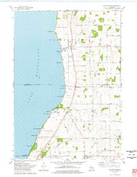
1974 Map of Brothertown
USGS Topo · Published 1978About this map
Lake Winnebago dominates the western shoreline of this mid-1970s survey, where a series of small beach communities and landing points line the water's edge. The settlement of Brothertown and the nearby Brothertown Harbor anchor the northern coast, while the Old Indian Treaty Boundary cuts across the landscape, marking the historic division between Calumet and Fond du Lac counties. This boundary line passes through Calumetville and near the Buck Cemetery, reflecting the early administrative and surveying history of the region.
Find a feature on this map
47 named features on this map. Tap any name to fly to it.
Don’t see what you’re looking for? This feature index may not catch every label — zoom into the map to look around manually.
Map Details
Editions of this 1974 Brothertown Map
This is the sole edition of this map. No revisions or reprints were ever made.
Other maps of this area

1910 · Fond du Lac
USGS Topo · 1:62,500

1911 · Neenah
USGS Topo · 1:62,500

1954 · Chilton
USGS Topo · 1:62,500

1954 · Kiel
USGS Topo · 1:62,500

1955 · Neenah
USGS Topo · 1:62,500

1955 · Fond Du Lac
USGS Topo · 1:62,500

1955 · Fond Du Lac
USGS Topo · 1:24,000

1955 · Green Bay
USGS Topo · 1:250,000

1957 · Madison
USGS Topo · 1:250,000

1960 · Madison
USGS Topo · 1:250,000