
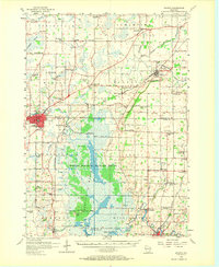
1955 Map of Waupun
USGS Topo · Published 1957About this map
The Horicon Marsh dominates the southern landscape of this mid-century survey, a sprawling wetland complex defined by the Main Ditch and numerous named landforms like Stony Island and Rank Island. At the heart of the region sits Waupun, a significant civic hub marked by the State Prison and State Hospital. The surrounding countryside of Fond du Lac and Dodge counties is a dense network of dairy-era rural infrastructure, including one-room schoolhouses like West Brick Sch and Maple Dale Sch, and local landmarks such as Wedge Prairie Cem. Industrial activity is evident at the Nashbro Quarry and various Quarries near Oakfield. The transportation corridor is anchored by the Chicago and North Western and Chicago Milwaukee St Paul and Pacific railroads, which facilitated the movement of goods from settlements like Kekoskee and Mayville to wider markets.
Find a feature on this map
83 named features on this map. Tap any name to fly to it.
Don’t see what you’re looking for? This feature index may not catch every label — zoom into the map to look around manually.
Map Details
Editions of this 1955 Waupun Map
2 editions found
Other maps of this area

1904 · Hartford
USGS Topo · 1:62,500

1910 · Fond du Lac
USGS Topo · 1:62,500

1916 · Ripon
USGS Topo · 1:48,000

1918 · Ripon
USGS Topo · 1:62,500

1955 · Beaver Dam
USGS Topo · 1:62,500

1955 · Campbellsport
USGS Topo · 1:62,500

1955 · Fox Lake
USGS Topo · 1:62,500

1955 · Fond Du Lac
USGS Topo · 1:62,500

1955 · Fond Du Lac
USGS Topo · 1:24,000

1955 · Horicon
USGS Topo · 1:62,500