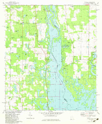
1982 Map of Fairchild
USGS Topo · Published 1983About this map
Lake Seminole dominates this landscape where the Chattahoochee River defines the border between Georgia and Florida. The creation of the reservoir altered the local topography, yet the map preserves the locations of established riverfront points like Butlers Ferry Landing and Parramore Landing. Inland, a dense network of smaller water bodies such as Boran Lake and Hettie Pond pepper the terrain, reflecting the wet, low-lying character of the region.
Find a feature on this map
58 named features on this map. Tap any name to fly to it.
Don’t see what you’re looking for? This feature index may not catch every label — zoom into the map to look around manually.
Map Details
Editions of this 1982 Fairchild Map
This is the sole edition of this map. No revisions or reprints were ever made.
Other maps of this area

1952 · Cypress
USGS Topo · 1:24,000

1952 · Dellwood
USGS Topo · 1:24,000

1952 · Bascom
USGS Topo · 1:24,000

1954 · Steam Mill
USGS Topo · 1:24,000

1954 · Sneads
USGS Topo · 1:24,000

1954 · Desser
USGS Topo · 1:24,000

1954 · Tallahassee
USGS Topo · 1:250,000

1955 · Fairchild
USGS Topo · 1:24,000

1955 · Reynoldsville
USGS Topo · 1:24,000

1955 · Chattahoochee
USGS Topo · 1:24,000