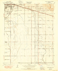
1950 Map of Fairfax School
USGS Topo · Published 1950About this map
The city of Bakersfield anchors the northwest corner of this 1950 survey, which captures the agricultural and industrial transition of Kern County. The landscape is defined by an intricate network of irrigation ditches, including the Eastside Canal and Kern Island Cottonwood Canal, which supported the region's expanding farm tracts. Transport routes such as the Southern Pacific railroad and the Southern Pacific Highway parallel the canal lines, facilitating the movement of goods from smaller rail stops like Magunden. Throughout the quadrangle, rural education centers serve as local landmarks, with the Fairfax School, Brundage Sch, and Mountain View Sch positioned along the grid of farm-to-market roads like Brundage Lane and Panama Lane. Near the southern boundary, the settlement of Lamont appears at a crossroads, while a Cem remains a permanent fixture near the urban fringe.
Find a feature on this map
38 named features on this map. Tap any name to fly to it.
Don’t see what you’re looking for? This feature index may not catch every label — zoom into the map to look around manually.
Map Details
Editions of this 1950 Fairfax School Map
This is the sole edition of this map. No revisions or reprints were ever made.
Other maps of this area

1906 · Bakersfield
USGS Topo · 1:62,500

1910 · Buena Vista Lake
USGS Topo · 1:125,000

1912 · Buena Vista Lake
USGS Topo · 1:125,000

1914 · Caliente
USGS Topo · 1:125,000

1929 · Fairfax School
USGS Topo · 1:31,680

1930 · Weed Patch
USGS Topo · 1:31,680

1930 · Arvin
USGS Topo · 1:31,680

1930 · Conner
USGS Topo · 1:31,680

1930 · Oildale
USGS Topo · 1:31,680

1931 · Edison
USGS Topo · 1:31,680