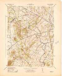
1944 Map of Fairfield
USGS Topo · Published 1944About this map
Gettysburg Natl Military Park occupies the eastern edge of this terrain, showing the western approach to the historic battlefield during the mid-1940s. The landscape is defined by the drainage of Marsh Creek and Middle Creek, which carve through a series of north-south ridges including McPherson Ridge and Kerr Hill. This period of Adams County history reveals a dense network of local education, with numerous rural schoolhouses such as Pitzer School, McCleary School, and Liberty Hall School serving the farming communities of Fairfield and McKnightstown. The Western Maryland railroad serves as a primary transport artery, connecting Orrtanna and Seven Stars to the regional economy. Notable landmarks like the State Hwy Maintenance Station and Camp George H Sharp highlight the infrastructure and military presence in the area as the mid-century era approached.
Find a feature on this map
45 named features on this map. Tap any name to fly to it.
Don’t see what you’re looking for? This feature index may not catch every label — zoom into the map to look around manually.
Map Details
Editions of this 1944 Fairfield Map
This is the sole edition of this map. No revisions or reprints were ever made.
Other maps of this area

1908 · Gettysburg
USGS Topo · 1:62,500

1909 · Fairfield
USGS Topo · 1:62,500

1911 · Taneytown
USGS Topo · 1:62,500

1911 · Emmitsburg
USGS Topo · 1:62,500

1942 · Gettysburg
USGS Topo · 1:125,000

1943 · Emmitsburg
USGS Topo · 1:62,500

1944 · Gettysburg
USGS Topo · 1:31,680

1944 · Flat Ridge
USGS Topo · 1:31,680
1944 · Blue Ridge Summit
USGS Topo · 1:31,680

1944 · Arendtsville
USGS Topo · 1:31,680
Featured Places
- Fairfield, PA
- Franklin Township, PA
- Hamiltonban Township, PA
- Cumberland Township, PA
- Liberty Township, PA