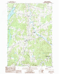
1986 Map of Fairfield
USGS Topo · Published 1986About this map
Fairfield serves as the central hub of this Vermont landscape, where the meandering course of Black Creek and Dead Creek define the low-lying terrain. The map captures the region in the mid-1980s, revealing a transition from the agricultural valley floor to the prominent rises of Sheldon Hill and Fox Hill. Large-scale conservation efforts are evident in the sprawling Fairfield Swamp State Wildlife Management Area to the west and the Elm Brook State Wildlife Management Area in the southeast.
Find a feature on this map
21 named features on this map. Tap any name to fly to it.
Don’t see what you’re looking for? This feature index may not catch every label — zoom into the map to look around manually.
Map Details
Editions of this 1986 Fairfield Map
2 editions found
Other maps of this area

1913 · Milton
USGS Topo · 1:48,000

1914 · St. Albans
USGS Topo · 1:48,000

1915 · Milton
USGS Topo · 1:62,500

1916 · St. Albans
USGS Topo · 1:62,500

1920 · Franklin Pond
USGS Topo · 1:62,500

1922 · Enosburg Falls
USGS Topo · 1:48,000

1924 · Enosburg Falls
USGS Topo · 1:62,500

1925 · Mount Mansfield
USGS Topo · 1:48,000

1927 · Mount Mansfield
USGS Topo · 1:62,500

1943 · St. Albans
USGS Topo · 1:62,500