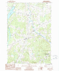
1986 Map of Fairfield
USGS Topo · Published 1986About this map
Fairfield serves as the central hub of this Vermont landscape in the mid-1980s, where the winding course of Black Creek and Dead Creek define the lowlands. The terrain is a mix of agricultural valleys and wooded rises like Fox Hill and Sheldon Hill, reflecting a traditional New England land-use pattern of dairy farming and forestry. Large conservation blocks are prominent, specifically the Fairfield Swamp State Wildlife Management Area and the Elm Brook State Wildlife Management Area, which preserve significant wetland habitats across the township boundaries.
Find a feature on this map
19 named features on this map. Tap any name to fly to it.
Don’t see what you’re looking for? This feature index may not catch every label — zoom into the map to look around manually.
Map Details
Editions of this 1986 Fairfield Map
2 editions found
Other maps of this area

1913 · Milton
USGS Topo · 1:48,000

1914 · St. Albans
USGS Topo · 1:48,000

1915 · Milton
USGS Topo · 1:62,500

1916 · St. Albans
USGS Topo · 1:62,500

1920 · Franklin Pond
USGS Topo · 1:62,500

1922 · Enosburg Falls
USGS Topo · 1:48,000

1924 · Enosburg Falls
USGS Topo · 1:62,500

1925 · Mount Mansfield
USGS Topo · 1:48,000

1927 · Mount Mansfield
USGS Topo · 1:62,500

1943 · St. Albans
USGS Topo · 1:62,500