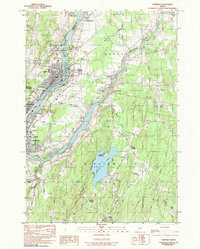
1982 Map of Fairfield
USGS Topo · Published 1991About this map
The Kennebec River serves as the central artery of this region, separating Fairfield from Benton and defining the industrial and transportation patterns of the early 1980s. The Maine Central RR runs parallel to the river's western bank, passing through the heart of Fairfield near Lawrence High Sch Ath Fld and Fairfield Park. The map documents a landscape where traditional small-town centers like Benton Station and Shawmut are connected by a network of rural routes such as Albion Road and Gogan Road.
Find a feature on this map
65 named features on this map. Tap any name to fly to it.
Don’t see what you’re looking for? This feature index may not catch every label — zoom into the map to look around manually.
Map Details
Editions of this 1982 Fairfield Map
2 editions found
Other maps of this area

1892 · Waterville
USGS Topo · 1:62,500

1893 · Vassalboro
USGS Topo · 1:62,500

1898 · Vassalboro
USGS Topo · 1:62,500

1916 · Liberty
USGS Topo · 1:62,500

1926 · Burnham
USGS Topo · 1:62,500

1941 · Vassalboro
USGS Topo · 1:62,500

1942 · Liberty
USGS Topo · 1:62,500

1943 · Vassalboro
USGS Topo · 1:62,500

1943 · Waterville
USGS Topo · 1:62,500

1948 · Bangor
USGS Topo · 1:250,000