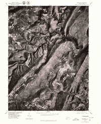
1977 Map of Fairhope
USGS Topo · Published 1979About this map
Allegheny Mountain and the deep, winding valley of a major Creek define the topography of this late 1970s orthophotoquad. This aerial perspective, prepared in cooperation with the Soil Conservation Service, reveals a landscape where steep wooded ridges isolate small, established communities. The settlement of Fairhope sits at a critical bend in the waterway, while other hamlets like Glencoe and Pinnells Mills are scattered along the narrow valley floors. The contrast between the dense forest of the Savage ridge and the cleared agricultural patches near Pleasant Union and Palo Alto provides a clear view of how Pennsylvania mountain terrain dictated 20th-century land use and settlement patterns.
Find a feature on this map
8 named features on this map. Tap any name to fly to it.
Don’t see what you’re looking for? This feature index may not catch every label — zoom into the map to look around manually.
Map Details
Editions of this 1977 Fairhope Map
This is the sole edition of this map. No revisions or reprints were ever made.
Other maps of this area

1898 · Frostburg
USGS Topo · 1:62,500

1899 · Flintstone
USGS Topo · 1:62,500

1900 · Flintstone
USGS Topo · 1:62,500

1901 · Frostburg
USGS Topo · 1:62,500

1908 · Frostburg
USGS Topo · 1:62,500

1923 · Berlin
USGS Topo · 1:48,000

1927 · Hyndman
USGS Topo · 1:62,500

1929 · Berlin
USGS Topo · 1:62,500

1931 · Hyndman
USGS Topo · 1:62,500

1944 · Hyndman
USGS Topo · 1:62,500
Featured Places
- Fairhope Township, PA
- Southampton Township, PA
- Palo Alto, Londonderry Township
- Allegheny Township, PA
- Northampton Township, PA