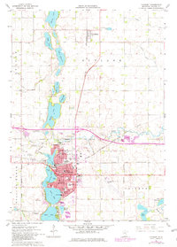
1967 Map of Fairmont
USGS Topo · Published 1979About this map
A chain of glacial lakes defines the north-south axis of this Martin County landscape, where the city of Fairmont is centered amidst George Lake, Sisseton Lake, Budd Lake, and Hall Lake. The late 1960s city layout shows a dense network of municipal services including the Hospital, an Armory, and multiple educational institutions such as Lincoln Sch and High Sch. The economy of the era is anchored by transportation and extraction, evidenced by the convergence of the Chicago and North Western and the Chicago Milwaukee St Paul and Pacific railroads near the Fairmont Municipal Airport, alongside numerous Gravel Pits distributed across the prairie.
Find a feature on this map
63 named features on this map. Tap any name to fly to it.
Don’t see what you’re looking for? This feature index may not catch every label — zoom into the map to look around manually.
Map Details
Editions of this 1967 Fairmont Map
3 editions found
Other maps of this area

1954 · Fairmont
USGS Topo · 1:250,000

1958 · Fairmont
USGS Topo · 1:250,000

1967 · Truman
USGS Topo · 1:24,000

1967 · East Chain
USGS Topo · 1:24,000

1967 · Wilmert Lake
USGS Topo · 1:24,000

1967 · Truman SE
USGS Topo · 1:24,000

1967 · Granada
USGS Topo · 1:24,000

1967 · Fairmont
USGS Topo · 1:24,000

1970 · St James SE
USGS Topo · 1:24,000

1970 · Welcome
USGS Topo · 1:24,000