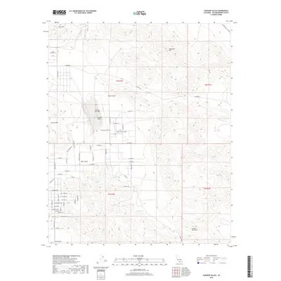
2018 Map of Fairview Valley
USGS Topo · Published 2018About this map
Fairview Valley occupies the center of this High Desert landscape, where the flat expanse of Fairview Dry Lake contrasts with the surrounding peaks. In this part of the Mojave Desert, the residential growth of Apple Valley pushes eastward into the foothills, marked by a tightening grid of roads like Cuyama Rd and Teepee Rd. The terrain is punctuated by isolated summits including Black Mtn, Sidewinder Mtn, and Fairview Mtn, while the southern boundary is defined by the Granite Mountains. Local hydrology is characterized by scattered points such as Quail Spring, Horse Spring, and McInnis Spring. Transportation in this era relies on long desert routes like Johnson Rd and Fairview Valley Rd, with the Holiday Ranch Airport serving as a remote aviation landmark.
Find a feature on this map
67 named features on this map. Tap any name to fly to it.
Don’t see what you’re looking for? This feature index may not catch every label — zoom into the map to look around manually.
Map Details
Editions of this 2018 Fairview Valley Map
This is the sole edition of this map. No revisions or reprints were ever made.
Other maps of this area

1901 · Southern California Sheet No. 1
USGS Topo · 1:250,000

1902 · Deep Creek
USGS Topo · 1:62,500

1902 · San Gorgonio
USGS Topo · 1:125,000

1904 · Southern California Sheet No. 1
USGS Topo · 1:250,000

1932 · Barstow
USGS Topo · 1:125,000

1934 · Barstow
USGS Topo · 1:125,000

1947 · Lucerne Valley
USGS Topo · 1:62,500

1949 · Lucerne Valley
USGS Topo · 1:62,500

1953 · San Bernardino
USGS Topo · 1:250,000

1955 · Ord Mountains
USGS Topo · 1:62,500