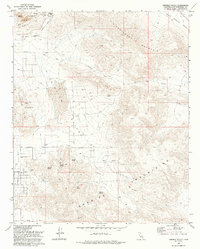
1993 Map of Fairview Valley
USGS Topo · Published 1993About this map
Industrial activity and high desert terrain converge in Fairview Valley during the late twentieth century. In the north, Black Mountain is heavily marked by extraction efforts, featuring a prominent Cement Plant, numerous Quarries, and extensive Mine Dumps. The landscape transitions from these industrial zones to the south, where the Granite Mountains rise above the valley floor. Water sources are critical in this arid environment, evidenced by a series of named desert springs including Quail Spring, Isabelle Spring, McInnis Spring, and Horse Spring. The area's infrastructure is defined by long, straight desert corridors such as Cahuilla Road and Johnson Road, while remote Landing Strips and the Red Top Mine suggest a region shaped by both utility and resource exploration.
Find a feature on this map
29 named features on this map. Tap any name to fly to it.
Don’t see what you’re looking for? This feature index may not catch every label — zoom into the map to look around manually.
Map Details
Editions of this 1993 Fairview Valley Map
This is the sole edition of this map. No revisions or reprints were ever made.
Other maps of this area

1901 · Southern California Sheet No. 1
USGS Topo · 1:250,000

1902 · Deep Creek
USGS Topo · 1:62,500

1902 · San Gorgonio
USGS Topo · 1:125,000

1904 · Southern California Sheet No. 1
USGS Topo · 1:250,000

1932 · Barstow
USGS Topo · 1:125,000

1934 · Barstow
USGS Topo · 1:125,000

1947 · Lucerne Valley
USGS Topo · 1:62,500

1949 · Lucerne Valley
USGS Topo · 1:62,500

1953 · San Bernardino
USGS Topo · 1:250,000

1955 · Ord Mountains
USGS Topo · 1:62,500