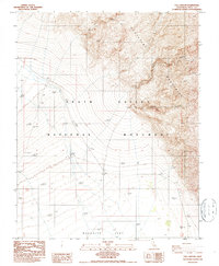
1986 Map of Fall Canyon
USGS Topo · Published 1986About this map
Death Valley National Monument dominates this desert landscape, where the dramatic elevation change between high peaks and low flats is clearly documented through 1980s-era topography. The Grapevine Mountains rise sharply to the east, dissected by deep drainages like Fall Canyon and Titus Canyon. These alluvial systems carry sediment down toward Mesquite Flat, illustrating the active geological processes that define this arid environment. To the north, Red Wall Canyon cuts through the steep terrain, showing the complex drainage patterns that lead into the valley floor. Compiled from aerial photography taken in the late 1970s and early 1980s, this record preserves the desert wilderness as it stood before many modern management shifts, providing a clear look at the township and range boundaries such as t13s t14s that still grid this expansive terrain.
Find a feature on this map
11 named features on this map. Tap any name to fly to it.
Don’t see what you’re looking for? This feature index may not catch every label — zoom into the map to look around manually.
Map Details
Editions of this 1986 Fall Canyon Map
2 editions found
Other maps of this area

1908 · Ballarat
USGS Topo · 1:250,000

1913 · Ballarat
USGS Topo · 1:250,000

1948 · Death Valley
USGS Topo · 1:250,000

1951 · Marble Canyon
USGS Topo · 1:62,500

1952 · Stovepipe Wells
USGS Topo · 1:62,500

1954 · Death Valley
USGS Topo · 1:250,000

1956 · Death Valley
USGS Topo · 1:250,000

1957 · Death Valley
USGS Topo · 1:250,000
1957 · Grapevine Peak
USGS Topo · 1:62,500

1957 · Tin Mountain
USGS Topo · 1:62,500