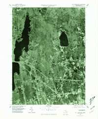
1977 Map of Fall River East
USGS Topo · Published 1981About this map
Westport Factory and the surrounding agricultural and industrial corridors of Bristol County appear in striking detail through this late-1970s orthophotograph. The landscape is dominated by the expansive waters of North Watuppa Pond and South Watuppa Pond, which flank the eastern edges of Fall River. This era of documentation shows the post-war highway infrastructure cutting through traditional crossroads like Beulah Corners and Hixville, illustrating the shift from isolated rural pockets to a more connected suburban-industrial network. Researchers can trace the path of the Shingle Island River as it winds toward the mill sites, alongside small residential developments at Lakeside and Collins Corner. The imagery provides a precise visual baseline of land use before the further commercialization of the late 20th century.
Find a feature on this map
9 named features on this map. Tap any name to fly to it.
Don’t see what you’re looking for? This feature index may not catch every label — zoom into the map to look around manually.
Map Details
Editions of this 1977 Fall River East Map
This is the sole edition of this map. No revisions or reprints were ever made.
Other maps of this area

1885 · New Bedford
USGS Topo · 1:62,500

1885 · Middleboro
USGS Topo · 1:62,500

1885 · Taunton
USGS Topo · 1:62,500

1888 · New Bedford
USGS Topo · 1:62,500

1888 · Fall River
USGS Topo · 1:62,500

1888 · Taunton
USGS Topo · 1:62,500

1888 · Middleboro
USGS Topo · 1:62,500

1893 · Taunton
USGS Topo · 1:62,500

1893 · Middleboro
USGS Topo · 1:62,500

1893 · Fall River
USGS Topo · 1:62,500