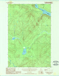
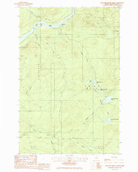
1987 Map of Falls Brook Lake
USGS Topo · Published 1987About this map
The St Francis River forms a natural international boundary between Maine and the Saint Francois Parish of New Brunswick at the northern edge of this late-twentieth-century survey. This remote timberland landscape is defined by its drainage basins and isolated water bodies, including Falls Brook Lake, Glazier Lake, and Little Falls Pond. The interior is crisscrossed by a network of private roads used for forestry access, connecting remote locations such as the Gravel Pit and various primitive Camp Sites along the waterways. To the south, the Little Black River winds through the township of Allagash, joined by smaller tributaries like Kelly Brook and Bass Brook. The presence of several notable streams, such as Yankeetuladi Brook and White Brook, illustrates the complex hydrological system that feeds into the border rivers, supporting the region's historic identity as a wilderness and resource-extraction zone.
Find a feature on this map
26 named features on this map. Tap any name to fly to it.
Don’t see what you’re looking for? This feature index may not catch every label — zoom into the map to look around manually.
Map Details
Editions of this 1987 Falls Brook Lake Map
This is the sole edition of this map. No revisions or reprints were ever made.
Other maps of this area

1930 · Allagash
USGS Topo · 1:48,000

1930 · St Francis
USGS Topo · 1:48,000

1933 · Allagash
USGS Topo · 1:62,500

1933 · St Francis
USGS Topo · 1:62,500

1955 · Beau Lake
USGS Topo · 1:62,500

1962 · Edmundston
USGS Topo · 1:250,000
1975 · St Francis SW
USGS Topo · 1:24,000
1975 · St Francis NW
USGS Topo · 1:24,000
1985 · St. Francis
USGS Topo · 1:24,000
1985 · Pelletier Brook Lakes
USGS Topo · 1:24,000