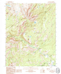
1992 Map of Falls Ridge
USGS Topo · Published 1995About this map
Falls Ridge dominates the central landscape of this high-altitude survey within the Yosemite National Park and Yosemite Wilderness. The terrain is defined by a dramatic hydraulic sequence along the Tuolumne River, where the water descends through Le Conte Falls, California Falls, and White Cascade. This area is a critical junction for backcountry travelers, anchored by the Glen Aulin High Sierra Camp and the intersection of the Pacific Crest National Scenic Trail near Glen Aulin. The map captures the complex alpine drainage system including Matterhorn Creek, Cathedral Creek, and Return Creek, feeding into high lakes like Rodgers Lake and Virginia Lake. It provides a technical record of the granite peaks and glacial valleys before late-century management changes, including the presence of a Sewage Disposal Pond near the Tuolumne meadows area.
Find a feature on this map
36 named features on this map. Tap any name to fly to it.
Don’t see what you’re looking for? This feature index may not catch every label — zoom into the map to look around manually.
Map Details
Editions of this 1992 Falls Ridge Map
2 editions found
Other maps of this area

1896 · Dardanelles
USGS Topo · 1:125,000

1897 · Yosemite
USGS Topo · 1:125,000

1898 · Dardanelles
USGS Topo · 1:125,000

1900 · Yosemite
USGS Topo · 1:125,000

1901 · Mt. Lyell
USGS Topo · 1:125,000

1903 · Yosemite
USGS Topo · 1:125,000

1909 · Yosemite
USGS Topo · 1:125,000

1909 · Bridgeport
USGS Topo · 1:125,000

1911 · Bridgeport
USGS Topo · 1:125,000

1920 · Bridgeport
USGS Topo · 1:125,000