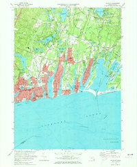
1972 Map of Falmouth
USGS Topo · Published 1974About this map
Falmouth and its surrounding coastal villages are shown in high detail during the early 1970s, a period marked by dense residential clusters and established civic infrastructure. The village centers of Teaticket, Mara Vista, and East Falmouth are clearly defined, while the peninsula character of the land is emphasized by the long, narrow bodies of water like Great Pond, Green Pond, and Bournes Pond reaching inland from Nantucket Sound. The map reveals a community supported by a mix of aviation at the Falmouth Airport, seasonal coastal life at Falmouth Heights, and active institutions such as Falmouth High Sch and Lawrence High Sch.
Find a feature on this map
106 named features on this map. Tap any name to fly to it.
Don’t see what you’re looking for? This feature index may not catch every label — zoom into the map to look around manually.
Map Details
Editions of this 1972 Falmouth Map
3 editions found
Other maps of this area

1886 · Falmouth
USGS Topo · 1:62,500

1887 · Marthas Vineyard
USGS Topo · 1:62,500

1888 · Barnstable
USGS Topo · 1:62,500

1888 · Falmouth
USGS Topo · 1:62,500

1889 · Marthas Vineyard
USGS Topo · 1:62,500

1893 · Barnstable
USGS Topo · 1:62,500

1893 · Falmouth
USGS Topo · 1:62,500

1894 · Marthas Vineyard
USGS Topo · 1:62,500

1915 · Falmouth
USGS Topo · 1:62,500

1920 · Falmouth
USGS Topo · 1:62,500