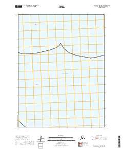
2020 Map of False Pass D-0 OE E NW
USGS Topo · Published 2020About this map
The vast Pacific Ocean dominates this maritime survey of the Aleutian landscape, where only the most prominent topographic markers break the water's surface. Situated within the townships of t60s r82w and t60s r81w, the map highlights navigational landmarks like John Rock and Olga Rock, which serve as critical orientation points in an otherwise open marine environment. This topographic record illustrates the sparse, rock-strewn character of the coastline in the Aleutians East region, where isolation is the primary geographic trait. The survey provides precise coordinates and contour data for these remote features, documenting the relationship between the few named landforms and the expansive surrounding seas during the early twenty-first century.
Find a feature on this map
5 named features on this map. Tap any name to fly to it.
Don’t see what you’re looking for? This feature index may not catch every label — zoom into the map to look around manually.
Map Details
Editions of this 2020 False Pass D-0 OE E NW Map
This is the sole edition of this map. No revisions or reprints were ever made.
Other maps of this area

1949 · False Pass
USGS Topo · 1:250,000

1950 · False Pass
USGS Topo · 1:250,000

1953 · Port Moller
USGS Topo · 1:250,000

1963 · Port Moller A-5
USGS Topo · 1:63,360

1963 · Port Moller A-6
USGS Topo · 1:63,360
1963 · False Pass D-0
USGS Topo · 1:63,360

1963 · Simeonof Island
USGS Topo · 1:250,000

1967 · Simeonof Island
USGS Topo · 1:250,000

1988 · Port Moller
USGS Topo · 1:250,000
2020 · False Pass D-0 OE E SW
USGS Topo · 1:25,000