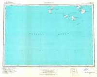
1963 Map of Simeonof Island
USGS Topo · Published 1968About this map
The Shumagin Islands are depicted during a period of mid-century maritime surveying, focusing on the isolated geography of the Pacific Ocean south of the Alaska Peninsula. Central to this map is Simeonof Island, largely encompassed by the Simeonof Nat Wildlife Rfg, an area established for the protection of sea otters and diverse avian life. The surrounding waters are charted with bathymetric soundings and depth curves, including the hazardous Twelve Fathom Strait and Otter Strait. To the west, the southern tip of Nagai Island is shown with landmarks such as Sadler Peak and the curiously named Saddlers Mistake. These islands represent a critical intersection of marine conservation and navigation, with smaller outposts like Chernabura Island and Bird Island providing vital data for the Usc&GS hydrographic charts of the 1960s.
Find a feature on this map
22 named features on this map. Tap any name to fly to it.
Don’t see what you’re looking for? This feature index may not catch every label — zoom into the map to look around manually.
Map Details
Editions of this 1963 Simeonof Island Map
3 editions found
Historical Maps of Aleutians East Through Time
384 maps found

1944 Cold Bay Sheet No. 1 of 25
Aleutians East Borough, AK

1944 Cold Bay Sheet No. 20 of 25
Aleutians East Borough, AK

1944 Cold Bay Sheet No. 2 of 25
Aleutians East Borough, AK

1949 Fort Randall
Aleutians East Borough, AK

1950 Fort Randall
Aleutians East Borough, AK

1951 Unimak
Aleutians East Borough, AK

1953 Port Moller
Aleutians East Borough, AK

1955 Beechey Point B-5
Aleutians East Borough, AK

1958 Unimak
Aleutians East Borough, AK

1958 Unimak B-2 NE
Aleutians East Borough, AK

1963 Chignik A-6
Aleutians East Borough, AK

1963 Chignik A-7
Aleutians East Borough, AK

1963 Chignik A-8
Aleutians East Borough, AK

1963 Chignik B-7
Aleutians East Borough, AK

1963 Chignik C-5
Aleutians East Borough, AK

1963 Chignik C-6
Aleutians East Borough, AK

1963 Chignik D-4
Aleutians East Borough, AK

1963 Cold Bay B-3
Aleutians East Borough, AK

1963 Cold Bay B-4
Aleutians East Borough, AK

1963 Cold Bay C-1
Aleutians East Borough, AK

1963 Cold Bay C-2
Aleutians East Borough, AK

1963 Cold Bay D-1
Aleutians East Borough, AK

1963 False Pass C-1
Aleutians East Borough, AK

1963 False Pass C-2
Aleutians East Borough, AK

1963 False Pass D-0
Aleutians East Borough, AK

1963 False Pass D-1
Aleutians East Borough, AK

1963 False Pass D-2
Aleutians East Borough, AK

1963 False Pass D-3
Aleutians East Borough, AK

1963 Port Moller A-1
Aleutians East Borough, AK

1963 Port Moller A-2
Aleutians East Borough, AK

1963 Port Moller A-3
Aleutians East Borough, AK

1963 Port Moller A-4
Aleutians East Borough, AK

1963 Port Moller A-5
Aleutians East Borough, AK

1963 Port Moller A-6
Aleutians East Borough, AK

1963 Port Moller B-1
Aleutians East Borough, AK

1963 Port Moller B-2
Aleutians East Borough, AK

1963 Port Moller C-1
Aleutians East Borough, AK

1963 Port Moller C-2
Aleutians East Borough, AK

1963 Port Moller C-5
Aleutians East Borough, AK

1963 Port Moller C-6
Aleutians East Borough, AK

1963 Port Moller D-1
Aleutians East Borough, AK

1963 Port Moller D-2
Aleutians East Borough, AK

1963 Port Moller D-3
Aleutians East Borough, AK

1963 Port Moller D-4
Aleutians East Borough, AK

1963 Port Moller D-5
Aleutians East Borough, AK

1963 Port Moller D-6
Aleutians East Borough, AK

1963 Simeonof Island
Aleutians East Borough, AK

1963 Simeonof Island D-1
Aleutians East Borough, AK

1963 Simeonof Island D-2
Aleutians East Borough, AK

1963 Simeonof Island D-3
Aleutians East Borough, AK

1963 Simeonof Island D-4
Aleutians East Borough, AK

1963 Stepovak Bay A-5
Aleutians East Borough, AK

1963 Stepovak Bay A-6
Aleutians East Borough, AK

1963 Stepovak Bay B-6
Aleutians East Borough, AK

1963 Stepovak Bay C-5 and C-6
Aleutians East Borough, AK

1963 Stepovak Bay D-6
Aleutians East Borough, AK

1967 Simeonof Island
Aleutians East Borough, AK

1983 Cold Bay A-1
Aleutians East Borough, AK

1983 Cold Bay B-1
Aleutians East Borough, AK

1983 Port Moller B-3
Aleutians East Borough, AK

1983 Port Moller B-4
Aleutians East Borough, AK

1983 Port Moller B-5
Aleutians East Borough, AK

1983 Port Moller B-6
Aleutians East Borough, AK

1983 Port Moller C-3
Aleutians East Borough, AK

1983 Port Moller C-4
Aleutians East Borough, AK

1988 Port Moller
Aleutians East Borough, AK

1989 Cold Bay A-6
Aleutians East Borough, AK

1989 False Pass B-2
Aleutians East Borough, AK

1989 False Pass B-3
Aleutians East Borough, AK

1989 False Pass C-4
Aleutians East Borough, AK

1989 False Pass C-5
Aleutians East Borough, AK

1989 False Pass C-6
Aleutians East Borough, AK

1989 False Pass D-6
Aleutians East Borough, AK

1989 Unalaska D-1
Aleutians East Borough, AK

1989 Unimak A-3
Aleutians East Borough, AK

1989 Unimak A-4
Aleutians East Borough, AK

1989 Unimak A-5
Aleutians East Borough, AK

1989 Unimak A-6
Aleutians East Borough, AK

1989 Unimak B-2
Aleutians East Borough, AK

1989 Unimak B-3
Aleutians East Borough, AK

1989 Unimak B-5
Aleutians East Borough, AK

1989 Unimak B-6
Aleutians East Borough, AK

1989 Unimak C-1
Aleutians East Borough, AK

1989 Unimak C-2
Aleutians East Borough, AK

1989 Unimak C-3
Aleutians East Borough, AK

1989 Unimak D-1
Aleutians East Borough, AK

1989 Unimak D-2
Aleutians East Borough, AK

1995 Cold Bay A-2
Aleutians East Borough, AK

1995 Cold Bay A-3
Aleutians East Borough, AK

1995 Cold Bay A-4
Aleutians East Borough, AK

1995 Cold Bay A-5
Aleutians East Borough, AK

1995 Cold Bay B-2
Aleutians East Borough, AK

1995 False Pass D-4
Aleutians East Borough, AK

1995 False Pass D-5
Aleutians East Borough, AK

2017 Sitka A-1 NW
Aleutians East Borough, AK

2020 Chignik A-6 NW
Aleutians East Borough, AK

2020 Chignik A-6 SW
Aleutians East Borough, AK

2020 Chignik A-7 NE
Aleutians East Borough, AK

2020 Chignik A-7 NW
Aleutians East Borough, AK

2020 Chignik A-7 SE
Aleutians East Borough, AK

2020 Chignik A-7 SW
Aleutians East Borough, AK

2020 Chignik A-8 NE
Aleutians East Borough, AK

2020 Chignik A-8 SE
Aleutians East Borough, AK

2020 Chignik B-6 NW
Aleutians East Borough, AK

2020 Chignik B-6 SW
Aleutians East Borough, AK

2020 Chignik B-7 NE
Aleutians East Borough, AK

2020 Chignik B-7 NW
Aleutians East Borough, AK

2020 Chignik B-7 OE W SW
Aleutians East Borough, AK

2020 Chignik B-7 SE
Aleutians East Borough, AK

2020 Chignik B-7 SW
Aleutians East Borough, AK

2020 Chignik C-4 NW
Aleutians East Borough, AK

2020 Chignik C-5 NE
Aleutians East Borough, AK

2020 Chignik C-5 NW
Aleutians East Borough, AK

2020 Chignik C-6 SE
Aleutians East Borough, AK

2020 Chignik C-6 SW
Aleutians East Borough, AK

2020 Chignik D-4 SE
Aleutians East Borough, AK

2020 Chignik D-4 SW
Aleutians East Borough, AK

2020 Cold Bay A-1 NE
Aleutians East Borough, AK

2020 Cold Bay A-1 NW
Aleutians East Borough, AK

2020 Cold Bay A-1 SE
Aleutians East Borough, AK

2020 Cold Bay A-1 SW
Aleutians East Borough, AK

2020 Cold Bay A-2 NE
Aleutians East Borough, AK

2020 Cold Bay A-2 NW
Aleutians East Borough, AK

2020 Cold Bay A-2 SE
Aleutians East Borough, AK

2020 Cold Bay A-2 SW
Aleutians East Borough, AK

2020 Cold Bay A-3 NE
Aleutians East Borough, AK

2020 Cold Bay A-3 NW
Aleutians East Borough, AK

2020 Cold Bay A-3 SE
Aleutians East Borough, AK

2020 Cold Bay A-3 SW
Aleutians East Borough, AK

2020 Cold Bay A-4 NE
Aleutians East Borough, AK

2020 Cold Bay A-4 NW
Aleutians East Borough, AK

2020 Cold Bay A-4 SE
Aleutians East Borough, AK

2020 Cold Bay A-4 SW
Aleutians East Borough, AK

2020 Cold Bay A-5 SE
Aleutians East Borough, AK

2020 Cold Bay A-5 SW
Aleutians East Borough, AK

2020 Cold Bay A-6 SE
Aleutians East Borough, AK

2020 Cold Bay A-6 SW
Aleutians East Borough, AK

2020 Cold Bay B-1 NE
Aleutians East Borough, AK

2020 Cold Bay B-1 NW
Aleutians East Borough, AK

2020 Cold Bay B-1 SE
Aleutians East Borough, AK

2020 Cold Bay B-1 SW
Aleutians East Borough, AK

2020 Cold Bay B-2 NE
Aleutians East Borough, AK

2020 Cold Bay B-2 NW
Aleutians East Borough, AK

2020 Cold Bay B-2 SE
Aleutians East Borough, AK

2020 Cold Bay B-2 SW
Aleutians East Borough, AK

2020 Cold Bay B-3 NE
Aleutians East Borough, AK

2020 Cold Bay B-3 SE
Aleutians East Borough, AK

2020 Cold Bay B-3 SW
Aleutians East Borough, AK

2020 Cold Bay B-4 NE
Aleutians East Borough, AK

2020 Cold Bay B-4 NW
Aleutians East Borough, AK

2020 Cold Bay C-1 NE
Aleutians East Borough, AK

2020 Cold Bay C-1 NW
Aleutians East Borough, AK

2020 Cold Bay C-1 SE
Aleutians East Borough, AK

2020 Cold Bay C-1 SW
Aleutians East Borough, AK

2020 Cold Bay C-2 SE
Aleutians East Borough, AK

2020 Cold Bay D-1 SE
Aleutians East Borough, AK

2020 False Pass B-2 NE
Aleutians East Borough, AK

2020 False Pass B-2 NW
Aleutians East Borough, AK

2020 False Pass B-2 SE
Aleutians East Borough, AK

2020 False Pass B-2 SW
Aleutians East Borough, AK

2020 False Pass B-3 NE
Aleutians East Borough, AK

2020 False Pass B-3 NW
Aleutians East Borough, AK

2020 False Pass B-3 SE
Aleutians East Borough, AK

2020 False Pass B-3 SW
Aleutians East Borough, AK

2020 False Pass B-4 SE
Aleutians East Borough, AK

2020 False Pass C-1 NE
Aleutians East Borough, AK

2020 False Pass C-1 NW
Aleutians East Borough, AK

2020 False Pass C-1 SE
Aleutians East Borough, AK

2020 False Pass C-1 SW
Aleutians East Borough, AK

2020 False Pass C-2 NE
Aleutians East Borough, AK

2020 False Pass C-2 SE
Aleutians East Borough, AK

2020 False Pass C-3 NW
Aleutians East Borough, AK

2020 False Pass C-3 SE
Aleutians East Borough, AK

2020 False Pass C-3 SW
Aleutians East Borough, AK

2020 False Pass C-4 NE
Aleutians East Borough, AK

2020 False Pass C-4 NW
Aleutians East Borough, AK

2020 False Pass C-5 NE
Aleutians East Borough, AK

2020 False Pass C-5 NW
Aleutians East Borough, AK

2020 False Pass C-5 SE
Aleutians East Borough, AK

2020 False Pass C-5 SW
Aleutians East Borough, AK

2020 False Pass C-6 NE
Aleutians East Borough, AK

2020 False Pass C-6 NW
Aleutians East Borough, AK

2020 False Pass D-0 NE
Aleutians East Borough, AK

2020 False Pass D-0 NW
Aleutians East Borough, AK

2020 False Pass D-0 OE E NW
Aleutians East Borough, AK

2020 False Pass D-0 OE E SW
Aleutians East Borough, AK

2020 False Pass D-0 SE
Aleutians East Borough, AK

2020 False Pass D-0 SW
Aleutians East Borough, AK

2020 False Pass D-1 NE
Aleutians East Borough, AK

2020 False Pass D-1 NW
Aleutians East Borough, AK

2020 False Pass D-1 SE
Aleutians East Borough, AK

2020 False Pass D-1 SW
Aleutians East Borough, AK

2020 False Pass D-2 NE
Aleutians East Borough, AK

2020 False Pass D-2 NW
Aleutians East Borough, AK

2020 False Pass D-2 SE
Aleutians East Borough, AK

2020 False Pass D-2 SW
Aleutians East Borough, AK

2020 False Pass D-3 NE
Aleutians East Borough, AK

2020 False Pass D-3 NW
Aleutians East Borough, AK

2020 False Pass D-3 SE
Aleutians East Borough, AK

2020 False Pass D-4 NE
Aleutians East Borough, AK

2020 False Pass D-4 NW
Aleutians East Borough, AK

2020 False Pass D-4 SE
Aleutians East Borough, AK

2020 False Pass D-4 SW
Aleutians East Borough, AK

2020 False Pass D-5 NE
Aleutians East Borough, AK

2020 False Pass D-5 NW
Aleutians East Borough, AK

2020 False Pass D-5 SE
Aleutians East Borough, AK

2020 False Pass D-5 SW
Aleutians East Borough, AK

2020 False Pass D-6 NE
Aleutians East Borough, AK

2020 False Pass D-6 NW
Aleutians East Borough, AK

2020 False Pass D-6 SE
Aleutians East Borough, AK

2020 False Pass D-6 SW
Aleutians East Borough, AK

2020 Port Moller A-1 NE
Aleutians East Borough, AK

2020 Port Moller A-1 NW
Aleutians East Borough, AK

2020 Port Moller A-1 SE
Aleutians East Borough, AK

2020 Port Moller A-1 SW
Aleutians East Borough, AK

2020 Port Moller A-2 NE
Aleutians East Borough, AK

2020 Port Moller A-2 NW
Aleutians East Borough, AK

2020 Port Moller A-2 SW
Aleutians East Borough, AK

2020 Port Moller A-3 NE
Aleutians East Borough, AK

2020 Port Moller A-3 NW
Aleutians East Borough, AK

2020 Port Moller A-3 SE
Aleutians East Borough, AK

2020 Port Moller A-4 NE
Aleutians East Borough, AK

2020 Port Moller A-4 NW
Aleutians East Borough, AK

2020 Port Moller A-5 NE
Aleutians East Borough, AK

2020 Port Moller A-5 NW
Aleutians East Borough, AK

2020 Port Moller A-5 SE
Aleutians East Borough, AK

2020 Port Moller A-5 SW
Aleutians East Borough, AK

2020 Port Moller A-6 NE
Aleutians East Borough, AK

2020 Port Moller A-6 NW
Aleutians East Borough, AK

2020 Port Moller A-6 SE
Aleutians East Borough, AK

2020 Port Moller A-6 SW
Aleutians East Borough, AK

2020 Port Moller B-1 NE
Aleutians East Borough, AK

2020 Port Moller B-1 NW
Aleutians East Borough, AK

2020 Port Moller B-1 SE
Aleutians East Borough, AK

2020 Port Moller B-1 SW
Aleutians East Borough, AK

2020 Port Moller B-2 NE
Aleutians East Borough, AK

2020 Port Moller B-2 NW
Aleutians East Borough, AK

2020 Port Moller B-2 SE
Aleutians East Borough, AK

2020 Port Moller B-2 SW
Aleutians East Borough, AK

2020 Port Moller B-3 NE
Aleutians East Borough, AK

2020 Port Moller B-3 NW
Aleutians East Borough, AK

2020 Port Moller B-3 SE
Aleutians East Borough, AK

2020 Port Moller B-3 SW
Aleutians East Borough, AK

2020 Port Moller B-4 NE
Aleutians East Borough, AK

2020 Port Moller B-4 NW
Aleutians East Borough, AK

2020 Port Moller B-4 SE
Aleutians East Borough, AK

2020 Port Moller B-4 SW
Aleutians East Borough, AK

2020 Port Moller B-5 NE
Aleutians East Borough, AK

2020 Port Moller B-5 NW
Aleutians East Borough, AK

2020 Port Moller B-5 SE
Aleutians East Borough, AK

2020 Port Moller B-5 SW
Aleutians East Borough, AK

2020 Port Moller B-6 NE
Aleutians East Borough, AK

2020 Port Moller B-6 NW
Aleutians East Borough, AK

2020 Port Moller B-6 SE
Aleutians East Borough, AK

2020 Port Moller B-6 SW
Aleutians East Borough, AK

2020 Port Moller C-1 NE
Aleutians East Borough, AK

2020 Port Moller C-1 NW
Aleutians East Borough, AK

2020 Port Moller C-1 SE
Aleutians East Borough, AK

2020 Port Moller C-2 NE
Aleutians East Borough, AK

2020 Port Moller C-2 NW
Aleutians East Borough, AK

2020 Port Moller C-2 SE
Aleutians East Borough, AK

2020 Port Moller C-2 SW
Aleutians East Borough, AK

2020 Port Moller C-3 NE
Aleutians East Borough, AK

2020 Port Moller C-3 NW
Aleutians East Borough, AK

2020 Port Moller C-3 SE
Aleutians East Borough, AK

2020 Port Moller C-3 SW
Aleutians East Borough, AK

2020 Port Moller C-4 NE
Aleutians East Borough, AK

2020 Port Moller C-4 NW
Aleutians East Borough, AK

2020 Port Moller C-4 SE
Aleutians East Borough, AK

2020 Port Moller C-4 SW
Aleutians East Borough, AK

2020 Port Moller C-5 NE
Aleutians East Borough, AK

2020 Port Moller C-5 NW
Aleutians East Borough, AK

2020 Port Moller C-5 SE
Aleutians East Borough, AK

2020 Port Moller C-5 SW
Aleutians East Borough, AK

2020 Port Moller C-6 NE
Aleutians East Borough, AK

2020 Port Moller C-6 NW
Aleutians East Borough, AK

2020 Port Moller C-6 SE
Aleutians East Borough, AK

2020 Port Moller C-6 SW
Aleutians East Borough, AK

2020 Port Moller D-1 NE
Aleutians East Borough, AK

2020 Port Moller D-1 NW
Aleutians East Borough, AK

2020 Port Moller D-1 SE
Aleutians East Borough, AK

2020 Port Moller D-1 SW
Aleutians East Borough, AK

2020 Port Moller D-2 NE
Aleutians East Borough, AK

2020 Port Moller D-2 NW
Aleutians East Borough, AK

2020 Port Moller D-2 SE
Aleutians East Borough, AK

2020 Port Moller D-2 SW
Aleutians East Borough, AK

2020 Port Moller D-3 NE
Aleutians East Borough, AK

2020 Port Moller D-3 NW
Aleutians East Borough, AK

2020 Port Moller D-3 OE N SE
Aleutians East Borough, AK

2020 Port Moller D-3 OE N SW
Aleutians East Borough, AK

2020 Port Moller D-3 SE
Aleutians East Borough, AK

2020 Port Moller D-3 SW
Aleutians East Borough, AK

2020 Port Moller D-4 NE
Aleutians East Borough, AK

2020 Port Moller D-4 NW
Aleutians East Borough, AK

2020 Port Moller D-4 OE N SE
Aleutians East Borough, AK

2020 Port Moller D-4 OE N SW
Aleutians East Borough, AK

2020 Port Moller D-4 SE
Aleutians East Borough, AK

2020 Port Moller D-4 SW
Aleutians East Borough, AK

2020 Port Moller D-5 NE
Aleutians East Borough, AK

2020 Port Moller D-5 NW
Aleutians East Borough, AK

2020 Port Moller D-5 SE
Aleutians East Borough, AK

2020 Port Moller D-5 SW
Aleutians East Borough, AK

2020 Port Moller D-6 NE
Aleutians East Borough, AK

2020 Port Moller D-6 NW
Aleutians East Borough, AK

2020 Port Moller D-6 SE
Aleutians East Borough, AK

2020 Port Moller D-6 SW
Aleutians East Borough, AK

2020 Simeonof Island D-1 NW
Aleutians East Borough, AK

2020 Simeonof Island D-1 SW
Aleutians East Borough, AK

2020 Simeonof Island D-2 NE
Aleutians East Borough, AK

2020 Simeonof Island D-2 SW
Aleutians East Borough, AK

2020 Simeonof Island D-3 NW
Aleutians East Borough, AK

2020 Simeonof Island D-3 SE
Aleutians East Borough, AK

2020 Simeonof Island D-4 NE
Aleutians East Borough, AK

2020 Simeonof Island D-4 NW
Aleutians East Borough, AK

2020 Simeonof Island D-4 SW
Aleutians East Borough, AK

2020 Stepovak Bay A-5 NE
Aleutians East Borough, AK

2020 Stepovak Bay A-5 NW
Aleutians East Borough, AK

2020 Stepovak Bay A-5 OE E SW
Aleutians East Borough, AK

2020 Stepovak Bay A-5 OE N SW
Aleutians East Borough, AK

2020 Stepovak Bay A-5 SE
Aleutians East Borough, AK

2020 Stepovak Bay A-5 SW
Aleutians East Borough, AK

2020 Stepovak Bay A-6 NE
Aleutians East Borough, AK

2020 Stepovak Bay A-6 NW
Aleutians East Borough, AK

2020 Stepovak Bay A-6 SE
Aleutians East Borough, AK

2020 Stepovak Bay A-6 SW
Aleutians East Borough, AK

2020 Stepovak Bay B-6 SW
Aleutians East Borough, AK

2020 Stepovak Bay C-5 NW
Aleutians East Borough, AK

2020 Stepovak Bay C-5 SW
Aleutians East Borough, AK

2020 Stepovak Bay C-6 NE
Aleutians East Borough, AK

2020 Stepovak Bay C-6 SE
Aleutians East Borough, AK

2020 Stepovak Bay D-5 SW
Aleutians East Borough, AK

2020 Stepovak Bay D-6 NW
Aleutians East Borough, AK

2020 Stepovak Bay D-6 SE
Aleutians East Borough, AK

2020 Stepovak Bay D-6 SW
Aleutians East Borough, AK

2020 Unalaska C-1 NE
Aleutians East Borough, AK

2020 Unalaska D-1 NE
Aleutians East Borough, AK

2020 Unalaska D-1 SE
Aleutians East Borough, AK

2020 Unalaska D-1 SW
Aleutians East Borough, AK

2020 Unimak A-3 NE
Aleutians East Borough, AK

2020 Unimak A-3 SW
Aleutians East Borough, AK

2020 Unimak A-4 NE
Aleutians East Borough, AK

2020 Unimak A-4 NW
Aleutians East Borough, AK

2020 Unimak A-4 SE
Aleutians East Borough, AK

2020 Unimak A-4 SW
Aleutians East Borough, AK

2020 Unimak A-5 NE
Aleutians East Borough, AK

2020 Unimak A-5 NW
Aleutians East Borough, AK

2020 Unimak A-5 SE
Aleutians East Borough, AK

2020 Unimak A-5 SW
Aleutians East Borough, AK

2020 Unimak A-6 NE
Aleutians East Borough, AK

2020 Unimak A-6 NW
Aleutians East Borough, AK

2020 Unimak A-6 SE
Aleutians East Borough, AK

2020 Unimak A-6 SW
Aleutians East Borough, AK

2020 Unimak B-2 NW
Aleutians East Borough, AK

2020 Unimak B-2 OE E NW
Aleutians East Borough, AK

2020 Unimak B-5 SE
Aleutians East Borough, AK

2020 Unimak B-5 SW
Aleutians East Borough, AK

2020 Unimak B-6 SE
Aleutians East Borough, AK

2021 Sitka A-1 NW
Aleutians East Borough, AK

2021 Unimak A-3 NW
Aleutians East Borough, AK

2021 Unimak B-2 NE
Aleutians East Borough, AK

2021 Unimak B-3 NE
Aleutians East Borough, AK

2021 Unimak B-3 NW
Aleutians East Borough, AK

2021 Unimak C-1 NE
Aleutians East Borough, AK

2021 Unimak C-1 NW
Aleutians East Borough, AK

2021 Unimak C-1 SE
Aleutians East Borough, AK

2021 Unimak C-1 SW
Aleutians East Borough, AK

2021 Unimak C-2 NE
Aleutians East Borough, AK

2021 Unimak C-2 NW
Aleutians East Borough, AK

2021 Unimak C-2 SE
Aleutians East Borough, AK

2021 Unimak C-2 SW
Aleutians East Borough, AK

2021 Unimak C-3 NE
Aleutians East Borough, AK

2021 Unimak C-3 NW
Aleutians East Borough, AK

2021 Unimak C-3 SE
Aleutians East Borough, AK

2021 Unimak C-3 SW
Aleutians East Borough, AK

2021 Unimak D-1 NE
Aleutians East Borough, AK

2021 Unimak D-1 NW
Aleutians East Borough, AK

2021 Unimak D-1 SE
Aleutians East Borough, AK

2021 Unimak D-1 SW
Aleutians East Borough, AK

2021 Unimak D-2 NE
Aleutians East Borough, AK

2021 Unimak D-2 NW
Aleutians East Borough, AK

2021 Unimak D-2 SE
Aleutians East Borough, AK

2021 Unimak D-2 SW
Aleutians East Borough, AK

2023 Port Moller A-2 NW
Aleutians East Borough, AK

2024 Sitka A-1 NW
Aleutians East Borough, AK