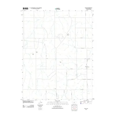
2012 Map of Falun
USGS Topo · Published 2012About this map
The unincorporated settlement of Falun serves as the focal point for this agrarian landscape in southwestern Saline County. Situated at the junction of Falun Rd and S Forsse Rd, the village contains a local Po and is surrounded by a grid of rural routes named for early settler families, such as Thorstenburg Rd and W Sundgren Rd. The topography is defined by several prominent landmarks that rise above the drainage basins of Ralston Cr and Spring Cr, including Soldier Cap Mound, Potato Hill, and Coiner Dome. To the south, the Dry Creek Cem sits near the headwaters of W Dry Cr, offering a point of interest for genealogists tracing the Swedish-American heritage of this region. The map captures a transition where the rolling prairie is dissected by narrow creek beds, showing a stable pattern of land use focused on large-scale agriculture and dispersed farmsteads.
Find a feature on this map
33 named features on this map. Tap any name to fly to it.
Don’t see what you’re looking for? This feature index may not catch every label — zoom into the map to look around manually.
Map Details
Editions of this 2012 Falun Map
This is the sole edition of this map. No revisions or reprints were ever made.
Other maps of this area

1892 · Salina
USGS Topo · 1:125,000

1942 · Salina
USGS Topo · 1:125,000

1955 · Salina SW
USGS Topo · 1:24,000

1955 · Smolan
USGS Topo · 1:24,000

1955 · Brookville
USGS Topo · 1:24,000

1955 · Falun
USGS Topo · 1:24,000

1955 · Hutchinson
USGS Topo · 1:250,000

1957 · Brookville SW
USGS Topo · 1:24,000
1957 · Venango
USGS Topo · 1:24,000

1959 · Hutchinson
USGS Topo · 1:250,000