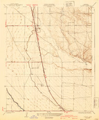
1930 Map of Famoso
USGS Topo · Published 1940About this map
The Southern Pacific railroad corridor serves as the backbone of this San Joaquin Valley landscape, where early 20th-century irrigation and transportation infrastructure converge. Surveyed in 1927, the map illustrates the critical role of water management in Kern County’s agricultural development, clearly marking the Lerdo Canal and Calloway Canal as they cut through the terrain west of the foothills. Small rail-side settlements and loading points like Famoso, Slater, and Kimberlina appear as focal points for local commerce and rural life. The junction of the Golden State Highway with regional routes like Wasco Road and Woody Road at Famoso highlights the area's importance as a transit hub, while the meander of Poso Creek provides a natural contrast to the strictly engineered grid of agricultural plots and canals that dominate the valley floor.
Find a feature on this map
12 named features on this map. Tap any name to fly to it.
Don’t see what you’re looking for? This feature index may not catch every label — zoom into the map to look around manually.
Map Details
Editions of this 1930 Famoso Map
2 editions found
Other maps of this area

1906 · Bakersfield
USGS Topo · 1:62,500

1910 · Buena Vista Lake
USGS Topo · 1:125,000

1912 · Buena Vista Lake
USGS Topo · 1:125,000

1927 · McFarland
USGS Topo · 1:31,680

1930 · McFarland
USGS Topo · 1:31,680

1930 · Wasco
USGS Topo · 1:31,680

1930 · Pond
USGS Topo · 1:31,680

1930 · Famoso
USGS Topo · 1:31,680

1930 · Rosedale
USGS Topo · 1:31,680

1930 · Oildale
USGS Topo · 1:31,680