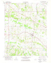
1977 Map of Fancy Farm
USGS Topo · Published 1977About this map
The unincorporated community of Fancy Farm serves as the focal point of this western Kentucky landscape, situated at the crossroads of local commerce and faith. Established as a Catholic colony, the area's spiritual roots are visible through landmarks like St Charles Ch and St Dennis Ch, along with numerous family burial grounds including Dodson Cem and Burgess Cem. The region is defined by the winding course of West Fork Mayfield Creek and its tributaries, which dictate the placement of farms and small settlements like Kirbyton and Beulah. Transportation and industry are represented by the Illinois Central Gulf railroad line cutting through the eastern portion of the quadrangle and a significant Pipeline corridor. This 1977 revision, based on earlier surveys and mid-1970s aerial photography, documents the rural infrastructure of Graves, Carlisle, and Hickman Counties during a period of established agricultural stability.
Find a feature on this map
30 named features on this map. Tap any name to fly to it.
Don’t see what you’re looking for? This feature index may not catch every label — zoom into the map to look around manually.
Map Details
Editions of this 1977 Fancy Farm Map
This is the sole edition of this map. No revisions or reprints were ever made.
Other maps of this area

1936 · Melber
USGS Topo · 1:24,000

1951 · Blandville
USGS Topo · 1:24,000

1951 · Milburn
USGS Topo · 1:24,000

1951 · Melber
USGS Topo · 1:24,000

1951 · Hickory
USGS Topo · 1:24,000

1951 · Hickory
USGS Topo · 1:62,500

1952 · Clinton
USGS Topo · 1:24,000

1952 · Mayfield
USGS Topo · 1:24,000

1952 · Dublin
USGS Topo · 1:24,000

1952 · Fancy Farm
USGS Topo · 1:24,000