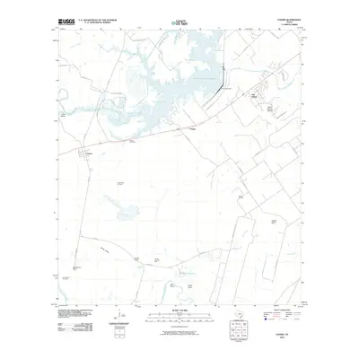
2010 Map of Fannin
USGS Topo · Published 2010About this map
Fannin and Cologne anchor this coastal plain landscape in Victoria County, where the sprawling Coleto Creek Cooling Pond and its Coleto Creek Dam dominate the northern terrain. The map captures a transition between traditional ranching, evidenced by the Swickheimer Ranch, and the industrial footprint of local energy production. Several active petroleum sites, including the Fannin East Oil Field, Battle Oil Field, and Cologne West Oil Field, are scattered across the quadrangle, illustrating the economic drivers of the region. Water remains a defining feature of the area, with the San Antonio River winding through the southwest corner and Onderdunk Lake providing a significant basin near Hall Point. Genealogists will find the Noble Cemetery and San Antonio Cemetery well-documented, while local historians can trace the network of rural routes like Fannin Rd and Cologne Rd that connect these small settlements and family-named landmarks.
Find a feature on this map
47 named features on this map. Tap any name to fly to it.
Don’t see what you’re looking for? This feature index may not catch every label — zoom into the map to look around manually.
Map Details
Editions of this 2010 Fannin Map
This is the sole edition of this map. No revisions or reprints were ever made.
Other maps of this area

1953 · Beeville
USGS Topo · 1:250,000

1956 · Beeville
USGS Topo · 1:250,000

1960 · Beeville
USGS Topo · 1:250,000

1962 · Live Oak Lake
USGS Topo · 1:24,000

1962 · Fannin
USGS Topo · 1:24,000

1962 · Lott Lake
USGS Topo · 1:24,000

1962 · McFaddin
USGS Topo · 1:24,000

1962 · Hensley Lake
USGS Topo · 1:24,000

1962 · Raisin
USGS Topo · 1:24,000
1963 · Ander
USGS Topo · 1:24,000