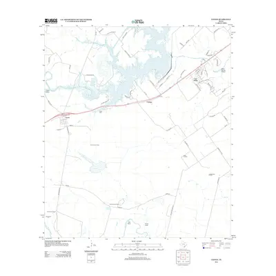
2013 Map of Fannin
USGS Topo · Published 2013About this map
Fannin sits at the junction of US Highway 59 N and Schroeder Road, serving as a primary settlement point in this Victoria County landscape. The area is defined by a mix of agricultural tradition and industrial resource extraction, notably marked by the Fannin East Oil Field and Battle Oil Field. Water dominates the northern and southern boundaries, from the expansive Coleto Cr Cooling Pond to the winding course of the San Antonio River. For genealogists and local historians, the presence of the Noble Cem near the town center and the San Antonio Cem further south provides a physical link to the early families of the region. The map also records smaller residential developments like Oak Village and established family holdings such as the Swickheimer Ranch, illustrating the transition from traditional ranching to modern suburban and industrial land use in south Texas.
Find a feature on this map
67 named features on this map. Tap any name to fly to it.
Don’t see what you’re looking for? This feature index may not catch every label — zoom into the map to look around manually.
Map Details
Editions of this 2013 Fannin Map
This is the sole edition of this map. No revisions or reprints were ever made.
Other maps of this area

1953 · Beeville
USGS Topo · 1:250,000

1956 · Beeville
USGS Topo · 1:250,000

1960 · Beeville
USGS Topo · 1:250,000

1962 · Live Oak Lake
USGS Topo · 1:24,000

1962 · Fannin
USGS Topo · 1:24,000

1962 · Lott Lake
USGS Topo · 1:24,000

1962 · McFaddin
USGS Topo · 1:24,000

1962 · Hensley Lake
USGS Topo · 1:24,000

1962 · Raisin
USGS Topo · 1:24,000
1963 · Ander
USGS Topo · 1:24,000