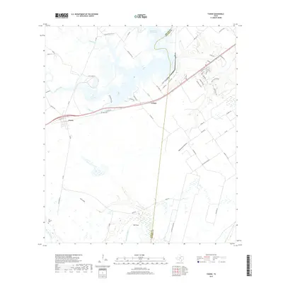
2019 Map of Fannin
USGS Topo · Published 2019About this map
Fannin and the surrounding coastal prairie of Victoria and Goliad counties are defined by a complex network of waterways and ranching heritage. The landscape is carved by the meandering San Antonio River at its southern edge, while the northern reaches are dominated by the large industrial footprint of the Coleto Creek Cooling Pond. This intersection of traditional rural life and modern utility is visible in the transition from family landmarks like Noble Cem and San Antonio Cem to the modern residential developments along Coleto Creek Dr. Numerous named drainage features, such as Portis Draw, Wade Reeves Hollow, and Kuu Cr, illustrate the subtle topographic shifts that dictate the local hydrology. Smaller settlements like Cologne remain as quiet outposts along the primary highway corridors, situated amidst long-established terrain features like Sand Hollow and Hall Point.
Find a feature on this map
60 named features on this map. Tap any name to fly to it.
Don’t see what you’re looking for? This feature index may not catch every label — zoom into the map to look around manually.
Map Details
Editions of this 2019 Fannin Map
This is the sole edition of this map. No revisions or reprints were ever made.
Other maps of this area

1953 · Beeville
USGS Topo · 1:250,000

1956 · Beeville
USGS Topo · 1:250,000

1960 · Beeville
USGS Topo · 1:250,000

1962 · Live Oak Lake
USGS Topo · 1:24,000

1962 · Fannin
USGS Topo · 1:24,000

1962 · Lott Lake
USGS Topo · 1:24,000

1962 · McFaddin
USGS Topo · 1:24,000

1962 · Hensley Lake
USGS Topo · 1:24,000

1962 · Raisin
USGS Topo · 1:24,000
1963 · Ander
USGS Topo · 1:24,000