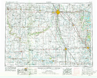
1953 Map of Fargo
USGS Topo · Published 1977About this map
The Red River of the North defines the border between North Dakota and Minnesota, anchoring the twin cities of Fargo and Moorhead. This mid-century landscape is dominated by a grid of agricultural settlements and a robust transportation network. Major rail lines including the Northern Pacific RR, Great Northern RR, and the Soo Line RR converge on the region's urban centers, facilitating the flow of grain from surrounding prairie towns like Casselton, Kindred, and Enderlin.
Find a feature on this map
160 named features on this map. Tap any name to fly to it.
Don’t see what you’re looking for? This feature index may not catch every label — zoom into the map to look around manually.
Map Details
Editions of this 1953 Fargo Map
2 editions found

Other maps of this area

1894 · Hecla
USGS Topo · 1:62,500

1894 · Oakes
USGS Topo · 1:62,500

1895 · Lamoure
USGS Topo · 1:125,000

1895 · Fargo
USGS Topo · 1:125,000

1895 · Casselton
USGS Topo · 1:125,000

1896 · Columbia
USGS Topo · 1:125,000

1897 · Fargo
USGS Topo · 1:125,000

1897 · Tower
USGS Topo · 1:125,000

1897 · Eckelson
USGS Topo · 1:125,000

1897 · Casselton
USGS Topo · 1:125,000