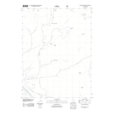
2011 Map of Farm Creek Peak
USGS Topo · Published 2011About this map
Farm Creek Peak anchors this high-elevation landscape in Duchesne County, where the transition from alpine terrain to managed water systems is clearly documented. The northern reaches are defined by natural features like Upper Basin and Rock Lake, with deep drainages such as Slide Canyon and Rough Canyon directing snowmelt toward the valley floor. The hydrology shifts from wild mountain streams like West Fork Farm Creek into a sophisticated irrigation network in the south.
Find a feature on this map
25 named features on this map. Tap any name to fly to it.
Don’t see what you’re looking for? This feature index may not catch every label — zoom into the map to look around manually.
Map Details
Editions of this 2011 Farm Creek Peak Map
This is the sole edition of this map. No revisions or reprints were ever made.
Other maps of this area

1885 · Uinta
USGS Topo · 1:250,000

1901 · Hayden Peak
USGS Topo · 1:125,000

1903 · Hayden Peak
USGS Topo · 1:125,000

1954 · Salt Lake City
USGS Topo · 1:250,000

1958 · Salt Lake City
USGS Topo · 1:250,000

1960 · Salt Lake City
USGS Topo · 1:250,000

1962 · Blacktail Mtn
USGS Topo · 1:24,000

1962 · Hanna
USGS Topo · 1:24,000

1962 · Tabiona
USGS Topo · 1:24,000
1962 · Tabby Mountain
USGS Topo · 1:24,000