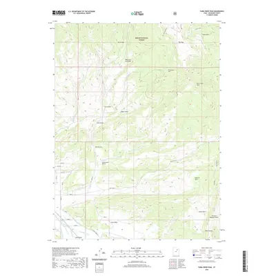
2020 Map of Farm Creek Peak
USGS Topo · Published 2020About this map
Ashley National Forest dominates the northern reaches of this landscape, where high ridgelines and deep canyons descend from Farm Creek Peak. The terrain is defined by a complex network of drainage systems, including the W Fork Farm Cr and E Fork Farm Cr, which transition into a sophisticated irrigation system as they reach the lower elevations. The southern portion of the map reveals the agricultural development of the Uinta Valley, where human engineering is evident in the extensive canal network. Settlers and ranchers utilized features like the Jasper Pike Canal, Farm Creek Canal, and Jesse Thomas Canal to divert water from the Duchesne River. This transition from the high-altitude wilderness of Rough Canyon and Winchester Flat to the managed water systems of the valley floor illustrates the critical reliance on mountain runoff for local life and industry.
Find a feature on this map
36 named features on this map. Tap any name to fly to it.
Don’t see what you’re looking for? This feature index may not catch every label — zoom into the map to look around manually.
Map Details
Editions of this 2020 Farm Creek Peak Map
This is the sole edition of this map. No revisions or reprints were ever made.
Other maps of this area

1885 · Uinta
USGS Topo · 1:250,000

1901 · Hayden Peak
USGS Topo · 1:125,000

1903 · Hayden Peak
USGS Topo · 1:125,000

1954 · Salt Lake City
USGS Topo · 1:250,000

1958 · Salt Lake City
USGS Topo · 1:250,000

1960 · Salt Lake City
USGS Topo · 1:250,000

1962 · Blacktail Mtn
USGS Topo · 1:24,000

1962 · Hanna
USGS Topo · 1:24,000

1962 · Tabiona
USGS Topo · 1:24,000
1962 · Tabby Mountain
USGS Topo · 1:24,000