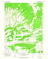
1962 Map of Farm Creek Peak
USGS Topo · Published 1964About this map
Ashley National Forest and the Uintah and Ouray Indian Reservation meet in this high-altitude landscape of northeast Utah, where the headwaters of Farm Creek descend toward the Duchesne River. The topography is defined by prominent elevations like Farm Creek Peak and sheltered areas such as Winchester Flat and Round Grove. In the southern portion of the quadrangle, a complex network of agricultural infrastructure is visible, including the Jasper Canal, Pike Canal, and Thomas Canal, which divert water to the local valley. Notable landmarks for local history include the remote Tonigut Basin and Shotnick Basin, along with several jeep trails that navigate the ridges and hollows, such as Cottonwood Hollow and Rough Canyon. The presence of a Prospect and a Corral in the high timber suggests the traditional land use patterns of mining and grazing that shaped the development of Duchesne County.
Find a feature on this map
36 named features on this map. Tap any name to fly to it.
Don’t see what you’re looking for? This feature index may not catch every label — zoom into the map to look around manually.
Map Details
Editions of this 1962 Farm Creek Peak Map
This is the sole edition of this map. No revisions or reprints were ever made.
Other maps of this area

1885 · Uinta
USGS Topo · 1:250,000

1901 · Hayden Peak
USGS Topo · 1:125,000

1903 · Hayden Peak
USGS Topo · 1:125,000

1954 · Salt Lake City
USGS Topo · 1:250,000

1958 · Salt Lake City
USGS Topo · 1:250,000

1960 · Salt Lake City
USGS Topo · 1:250,000

1962 · Blacktail Mtn
USGS Topo · 1:24,000

1962 · Hanna
USGS Topo · 1:24,000

1962 · Tabiona
USGS Topo · 1:24,000
1962 · Tabby Mountain
USGS Topo · 1:24,000